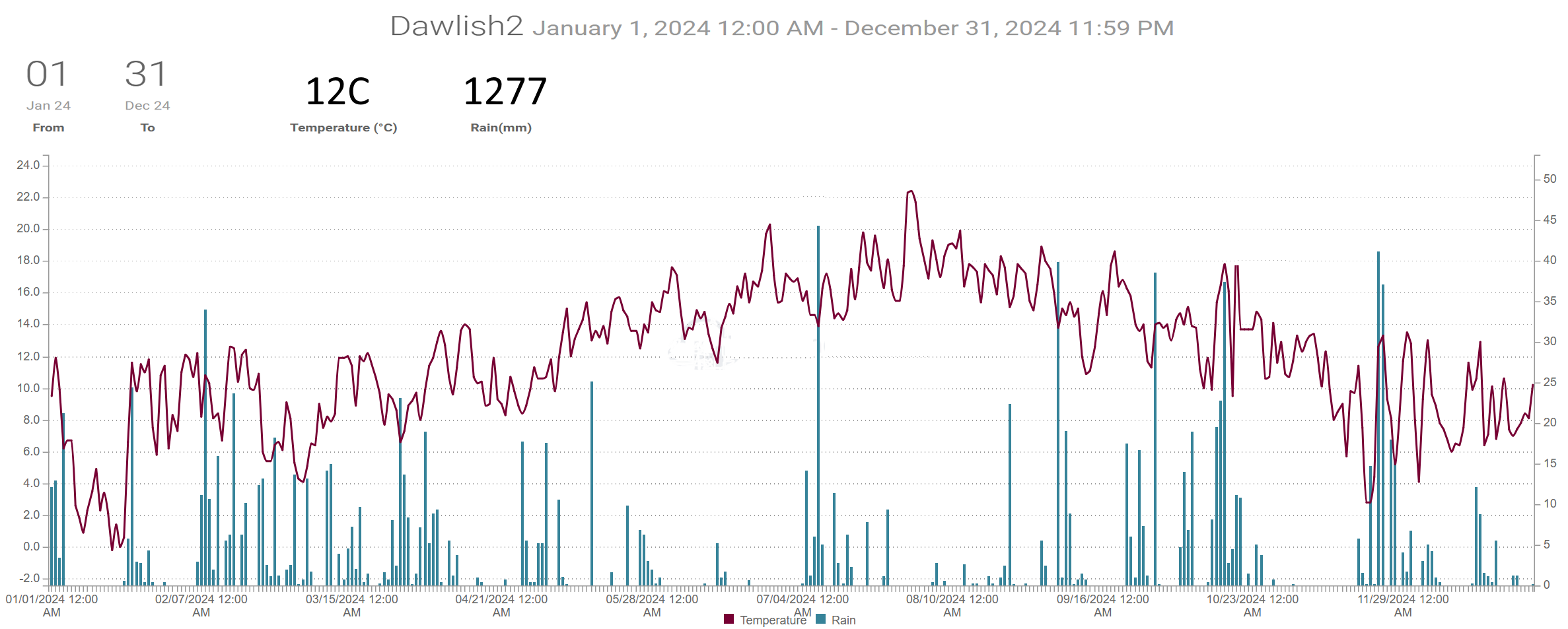
Weather Summary YEAR 2024 updated 240125 with Den figures
2024 Was slightly milder but much cloudier and wetter than the 30year average. There were more rain days and more days with 10mm or more but a similar number of dry days. This continues the trend to milder, cloudier and wetter years (heavy rainfall) as seen in the average 1981 to 2010 compared to 1991 to 2020
When shown * estimates were made using reports from nearby sites in order to calculate missing data. Grass frost estimates use air temp below 4C
Dawlish inland.
Average temp 12C. Air frost 17days. Ground frost possible 62 days.
Total rain 1277mm. 185 dry days, 143 days with 1mm or more, 45 days 10mm or more, 15 days 20mm or more.
Digital sun 1853 hours (corrected) = 1499 hours.
Teignmouth Den. 240125
Mean temperature 11.7C (LTA 11.7C). Average Max 15.4C (LTA 15C). Average Min 8C (LTA 8.4C). Air frost 11. (LTA 11).
Total rain 1342mm (LTA 873mm). 190 dry days (LTA 185), 136 days with 1mm or more (LTA 124). 42 days with >= 10mm (LTA 30). 23 days with >= 20mm.
Total sun *1613 hours (LTA 1737 hours).
Teignmouth Inland.
Average temp 12.9C. Air frost 6days. Ground frost possible 41 days.
Total rain 1206mm. 163 dry days, 136 days, with 1mm or more, 42 days 10mm or more, 15 days 20mm or more.
Digital sun 2263 hours (corrected) = 1428 hours.
Netherton.
Average temp 11.5C. Air frost 31days. Ground frost possible 82 days.
Total rain 1444mm. 172 dry days, 142days with 1mm or more, 51days 10mm or more, 19 days 20mm or more.
Digital sun 1983 hours (corrected) = 1541 hours.
Weather Summary December 2024 010125
Low pressure crossed Scotland on the 1st to be followed by colder NW winds and a weak ridge of higher pressure and this resulted in the coldest morning of the month being on the 3rd for most parts of the district. Fair weak Atlantic weather fronts brough some rain between the 4th and 8th during which named storm Darragh crossed Ireland overnight on the 6/7th bringing heavy rain and severe gales. Red and Amber warnings for wind where in force and many parts of the SW had winds of severe gale strength leading to the loss of power and several fallen trees. The highest gust of 96 mph (154 km/h) was recorded at Berry Head and gusts 60 to 80mph occurred widely. Across the UK there were three fatalities, and 1.87 million power outages were notified. High pressure followed across the UK resulting in a dry period between the 9th and 15th during which there were unusually light winds. Another windy period with rain occurred as low pressure moved over NW Scotland on the 17/18th and this turned out to be the wettest part of the month with further wind and rain occurring through to the 22nd. Pressure remained fairly high for the rest of the month with only light rain or drizzle thought not many sunny days. Pressure fell again on the 31st ahead of another low pressure which brought heavy rain and gales across the northern half of UK resulting in the cancellation of planned New Years Eve events. The gales and heavy rain reached the SW overnight and led to the cancellation of some outdoor events on the 1st.
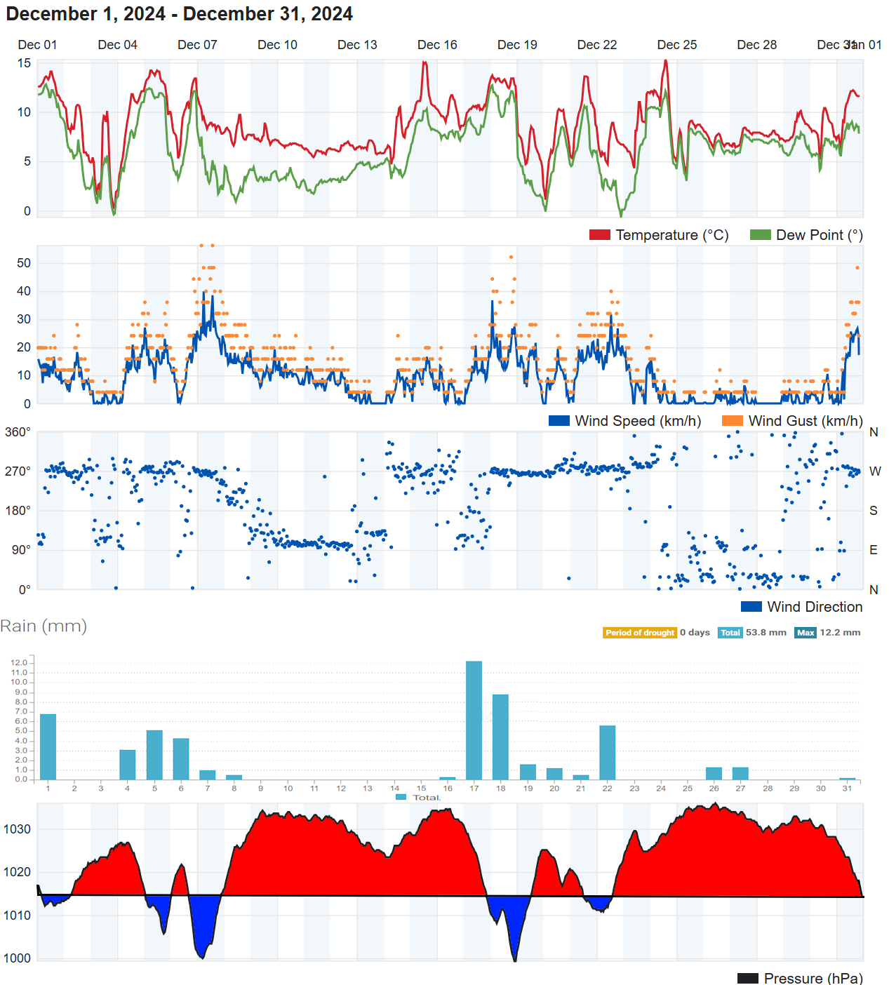
For a chart sequence for December click here
In terms of statistics:
The mean temperature for the month was 8.5 to 9 Celsius, which was a degree or so higher than the 30 year average. The mildest day for most was on the 24th when temperatures reached around 15 Celsius, although there were similar temperatures on the 1st and 15th. The coldest morning was on the 3rd with values 1 to 3 Celsius. Although one or two colder valleys managed an air frost most places might have a had a ground frost on a few nights during the month. Netherton, being in a colder valley, recorded 3 air frosts and as many as 9 ground frosts.
Rainfall totals in the Teignmouth and Dawlish area ranged from 28 to 68mm, well below the average of around 102mm. There were 11 to 16 days with no recoded rainfall, with the 9th to 15th being the driest period. There were 10 to 13 days with 1mm or more of rain which was slightly below the thirty year average. Most places had one day with 10mm or more recorded (average 4 days) and this was on the 17th when rainfall totals were between 8 and 12mm.
It was windy on several occasions 6/7th, 17/18th, 21/22nd and later the 31st.
Sunshine estimated 30 to 40 hours, well below average for December.
The sea temperature at the Dawlish wave buoy fell from 12.5 Celsius to 10.5 Celsius by the end of the month. The buoy recorded maximum wave heights of just 3.6 metres on the 1st , 2.9 metres on the 4th ahead of storm Darragh (the wind direction on the 7th was offshore during the storm hence less waves). Heights of 2.6 metres recorded on the 18th.
In summary, December 2024 was cloudier, milder and much drier than average. (Drier in terms of the number of dry days but more especially due rainfall amounts being about half the average).
When shown * estimates were made using reports from nearby sites in order to calculate missing data. Grass frost estimates use air temp below 4C
Kenton
Average temp 8.5C. Air frost 0days. Ground frost possible 4 days. Highest 15.4 on 1st. Lowest 0.4C morning of 3rd.
Total rain 48.8mm. 12 dry days, 13 days with 1mm or more, 0 days 10mm or more, 0 days 20mm or more. Wettest day 7.9 on 17th.
Dawlish inland.
Average temp 8.5C. Air frost 1days. Ground frost possible 4 days. Highest 15.3C on 24th Lowest 0.0C morning of 3rd.
Total rain 53.8mm. 15 dry days, 12 days with 1mm or more, 1 days 10mm or more, 0 days 20mm or more. Wettest day 12.2mm 17th .
Digital sun 9 hours (correction factor 2) = 18 hours.
Teignmouth Den.
Mean temperature 8.6C (LTA 7.5C). Average Max 11.2C (LTA 10.4C). Highest 15.1C on 4th and 6th. Average Min 6.1C (LTA 4.6C). Lowest 1.8C on 3rd. Air frost 0. (Average 3). Potential 2 ground frosts
Total rain 51.2mm (LTA 101.3mm). 12 dry days (LTA 14), 12 days with 1mm or more (LTA 13). Wettest day 12.5mm on the 17th 0900 to 0900 hours next day. 1 day with >= 10mm (LTA 4). 0 days with >= 20mm.
Total sun *50.2 hours (LTA 59.2 hours).
Teignmouth Inland.
Average temp 8.7C. Air frost 0 days. Ground frost possible 4 days. Highest 14.7C on 15th. Lowest 2.2C morning of 20th.
Total rain 48.3mm. 9 dry days, 10 days, with 1mm or more, 1 day 10mm or more, 0 days 20mm or more. Wettest day 10.2mm 17th .
Digital sun 55.3 hours (correction factor 0.7) = 38.5 hours.
Bitten Park.
Average temp 8.9C. Air frost 0days. Ground frost possible 4 days. Highest 14.7C on 1st. Lowest 2.7C morning of 3rd.
Total rain 44mm. 15 dry days, 10 days with 1 mm or more, 1 day 10mm or more, 0 days 20mm or more. Wettest day 11.2mm on 17th.
Netherton.
Average temp 8.3C. Air frost 3 days. Ground frost possible 9 days. Highest 15C on 24th. Lowest -1.2C morning of 3rd.
Total rain 67.8mm. 14 dry days, 12 days with 1mm or more, 2 days 10mm or more, 0 days 20mm or more. Wettest day 14.2mm 17th .
Digital sun 6 hours (correction factor 2) = 12 hours.
Weather Summary Autumn 2024 021224
Autumn was marginally milder than average but was cloudier and much wetter in terms of rainfall total and number of days with 10mm or more although the number of dry days was only slightly below average.
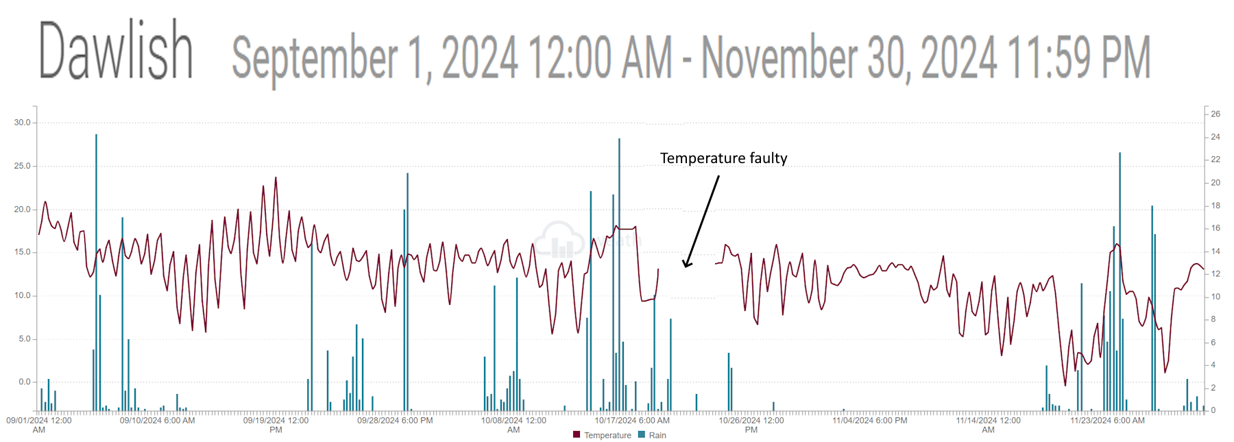
When shown * estimates were made using reports from nearby sites in order to calculate missing data. Grass frost estimates use air temp below 4C
Dawlish inland.
Average temp 12.5C. Air frost 2 days. Ground frost possible 9 days.
Total rain 474mm. 45 dry days, 37 days with 1mm or more, 17 days 10mm or more, 6 days 20mm or more. Digital sun 274 corrected hours.
Teignmouth Den. 240125
Mean temperature 12.1C (LTA 12.4C). Average Max 15.8C (LTA 15.5C). Average Min 8.3C (LTA 9.2C). Air frost 0. (Average 1). Potential 8 ground frosts
Total rain 505.5mm (LTA 250mm). 41 dry days (44), 34 days with 1mm or more (LTA 34). 16 day with >= 10mm (LTA 9.5). 9 days with >= 20mm.
Total sun 271.5 hours (LTA 356 hours).
Teignmouth Inland.
Average temp 12.9C. Air frost 1 day. Ground frost possible 6 days.
Total rain 442mm. 35 dry days, 39 days, with 1mm or more, 16 days 10mm or more, 6 days 20mm or more. Digital sun 278 corrected hours.
Netherton.
Average temp 11.8C. Air frost 4days. Ground frost possible 19 days.
Total rain 493mm. 39 dry days, 38 days with 1mm or more, 17 days 10mm or more, 8 days 20mm or more.
Weather Summary November 2024 021224
High pressure dominated the weather pattern through to the 17th although the first high migrated east into Europe allowing a weak weather front to cross from the west on the 10th/11th. This change allowed the dull cloudy skies of anticyclonic gloom to clear. A further high pressure followed this front from the west, the centre moving across England for a time before giving way to Atlantic weather systems from the 17th. Up until this time apart from light drizzle there had been little in the way of rain and no rain days (1mm or more). Low pressure and associated fronts crossed southern England over the subsequent few days ending with a cold northerly and a significant drop in temperature, some snow showers for the moors and an air frost for many on the 20th. A developing low-pressure rain quickly east along the English Channel on the 21st bring some wet weather and a period of snow over the moors and some wet snow for low lying areas too. Much milder wet and windy weather soon followed as storm Bert brought gales and very heavy rain across SW England. A brief respite on the 25th was followed by two more wet days on the 26th and 27th as a storm named Conell moved east over the south of England before developing over the southern North Sea. Higher pressure developed to the rear of this storm before cloudy weather with rain returned to end the month.
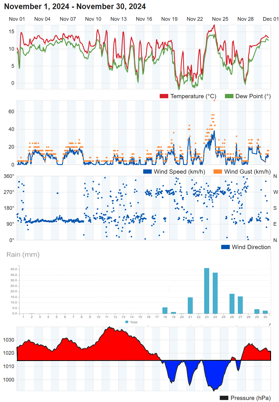
For a chart sequence for November click here
In terms of statistics:
The temperature for the month averaged around 10 Celsius, a half to one degree Celsius above the long-term average (LTA). The day with the highest temperature of around 17 Celsius was the 24th and the coldest morning with between 1 and minus 1 Celsius was the 20th or 21st. Many area just avoided an air frost but the colder inland valleys had 2 to 4 nights with an air frost. There were between 4 and 14 nights where a ground frost was possible across the district.
Rainfall totals in the Teignmouth and Dawlish area ranged from 120 to 160mm, well above the average of around 95mm. There was about 9 days with 1mm or more of rain which compares to an average of about 13 days, 5 days with 10mm or more (average 3 or 4 days) and one to three days with 20mm or more. Despite above average rainfall there was as many as 18 days with no recorded rain (LTA 13).
It was windy on several occasions in the second half of the month but more especially on the 23 and 24th in associated with storm Bert.
Sunshine estimated at 25 and 50 hours was less than half the average for November.
The sea temperature at the Dawlish wave buoy fell from 14.5 Celsius to 12.5 Celsius by the end of the month. The buoy recorded maximum wave heights of just under five metres on the 23rd and 24th.
In summary, November 2024 was a cloudy, mild, “dry and wet” month. (Drier in terms of the number of dry days and wetter in terms of rainfall total).
When shown * estimates were made using reports from nearby sites in order to calculate missing data. Grass frost estimates use air temp below 4C
Kenton.
Average temp 9.4C. Air frost 3days. Ground frost possible 11 days. Highest 17C on 24th. Lowest -1.6C morning of 20th.
Total rain 142mm. 14 dry days, 9 days with 1mm or more, 4 days 10mm or more, 2 days 20mm or more. Wettest day 39.8mm on 24th.
Digital sun 22.7 hours (correction factor 1.5) = 34 hours.
Dawlish inland.
Average temp 9.7C. Air frost 2days. Ground frost possible 8 days. Highest 17C on 24th. Lowest -1C morning of 20th.
Total rain 144mm, (no lying snow). 18 dry days, 9 days with 1mm or more, 5 days 10mm or more, 2 days 20mm or more. Wettest day 40mm 23rd.
Digital sun 27.8 hours (correction factor 1.5) = 42 hours.
Teignmouth Den. 240125
Mean temperature 10.4C (LTA 9.4C). Average Max 13C (LTA 12.3C). Highest 17.5C on 23rd. Average Min 7.8C (LTA 6.5C). Lowest 1.1C on 20th. Air frost 0. (Average 1). Potential 4 ground frosts.
Total rain 46.8mm (LTA 93mm). 15 dry days (LTA 13 days), 10 days with 1mm or more (LTA 13). Wettest day 44.1mm on the 26th 0900 to 0900 hours next day. 4 days with >= 10mm (LTA 3 or 4). 3 days with >= 20mm.
Total sun 46.8 hours (LTA 82 hours).
Teignmouth Inland.
Average temp 10.3C. Air frost 1 day. Ground frost possible 6 days. Highest 17.1C on 24th. Lowest -0.2C morning of 20th.
Total rain 132mm. 13 dry days, 10 days, with 1mm or more, 5 days 10mm or more, 3 days 20mm or more. Wettest day 37.1mm 23rdh .
Digital sun 55.6 hours (correction factor 0.7) = 39 hours.
Bitten Park.
Average temp 10.5C. Air frost 0days. Ground frost possible 6 days. Highest 17.1C on 24th. Lowest 0.1C morning of 20th.
Total rain 134mm. 16 dry days, 9 days with 1 mm or more, 5 days 10mm or more, 3 days 20mm or more. Wettest day 36mm on 23rd.
Netherton.
Average temp 9.5C. Air frost 4 days. Ground frost possible 14 days. Highest 17.1C on 24th. Lowest -3.2C morning of 20th.
Total rain 169mm. 16 dry days, 10 days with 1mm or more, 5 days 10mm or more, 3 days 20mm or more. Wettest day 46.2mm 24th.
Digital sun 22.3 hours (correction factor 1.5) = 33 hours.
Weather Summary October 2024 041124
The first four days were the driest part of the month as low pressure moved away eastwards and a high built across Scotland. By the 5th the high had moved to Denmark and low pressure was starting to move in from the Atlantic bringing several days of quite heavy rain. The low and its associated fronts move east to allow a brief drier interval before low pressure moved from Biscay, on the 12th, across England and into the North Sea by the 13th. High pressure developed to the east and this held back the Atlantic fronts, unfortunately they were held back over the west of the UK. A series of thundery bands of rain spread north from France before clearing east on the 17th but only to make way for further Atlantic weather fronts. On the 20th named storm Ashley developed to the west of Ireland and moved across the north of Scotland on the 21st. Ashley brought gales and rain across the district before ending the very wet spell between the 13th and 20th. High pressure developed to the south for a time before another low pressure and frontal systems approached the area on the 24/25th. Unusually this low moved south rather than crossing the UK. Although high pressure then lasted to the end of the month it was often rather cloudy.
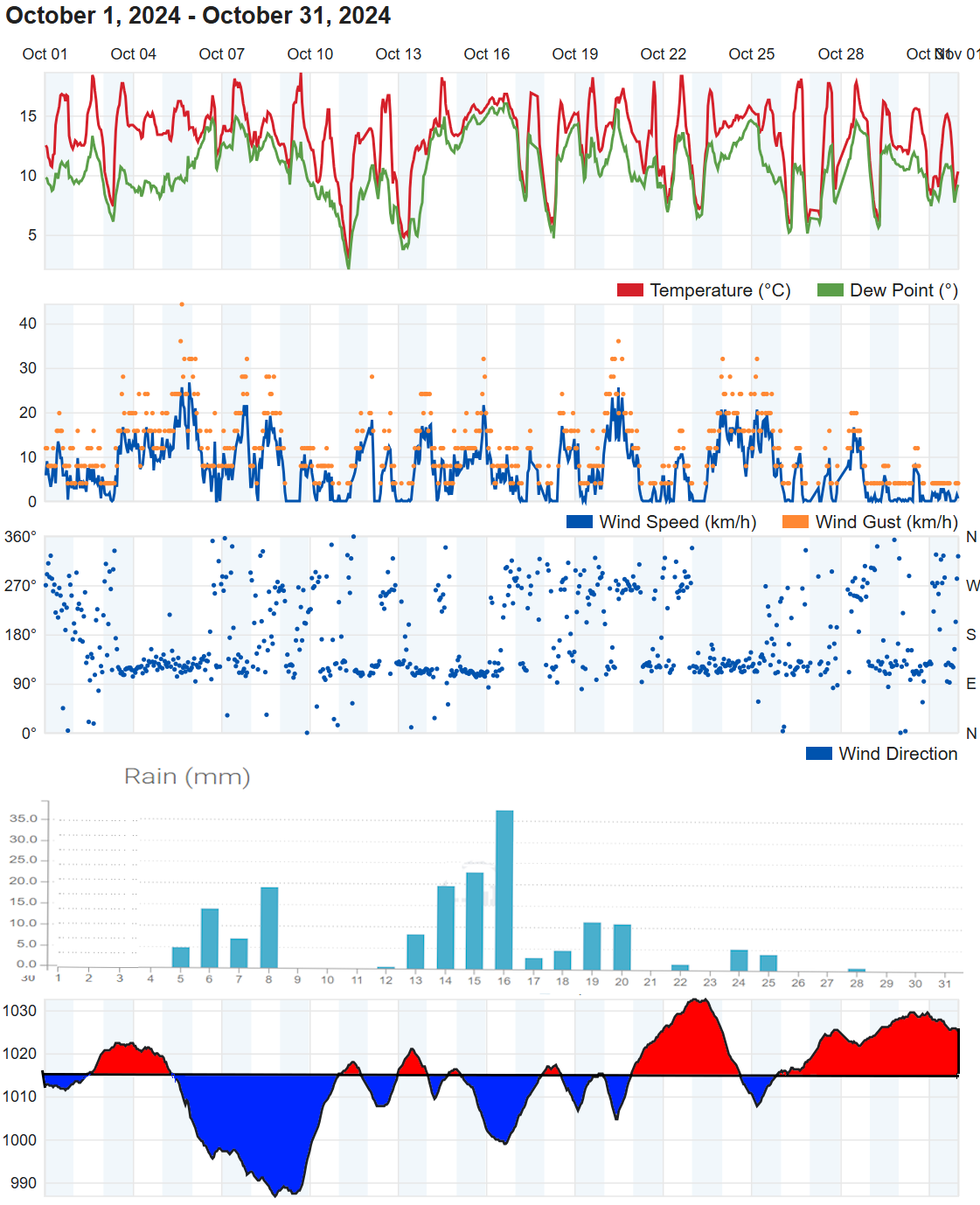
For a chart sequence for October click here
In terms of statistics:
The temperature for the month averaged between 13 and 14 Celsius, about a degree above the long term average (LTA). The days with the highest temperature of around 19 Celsius varied across the district, most commonly the 17th but 7th, 9th, 14th, 17th and 19th were all contenders for the warmest day. There was good agreement for the coldest morning which was on the 11th with values between 5 and 1 Celsius recorded. The lower values being in inland valleys where one or two nights could have had a ground frost.
Rainfall totals in the Teignmouth and Dawlish area ranged from 130 to 170mm, well above the average of around 100mm. There was about 15 days with 1mm or more of rain which compares to an average of about 12 days, 6 days with 10mm or more (average 3 or 4 days) and 1 or 2 days with 20mm or more. There was about 13 dry days (14).
It was windy on several occasions 5/6th, 20/21st and 23/25th across the district.
Sunshine estimated at around 100 hours was very slightly the average of 114 hours.
The sea temperature at the Dawlish wave buoy fell to 14.5 Celsius by the end of the month. The buoy recorded maximum wave heights of just under four metres on the 20th.
In summary, October 2024 was milder and wetter than average.
When shown * estimates were made using reports from nearby sites in order to calculate missing data. Grass frost estimates use air temp below 4C
Exminster.
Average temp 13.1C. Air frost 0 days. Ground frost possible 1 days. Highest 23.7C on 19th. Lowest 1.9C morning of 11th.
Total rain 164.3mm. 13 dry days, 13 days with 1mm or more, 6 days 10mm or more, 2 days 20mm or more. Wettest day 27.4 on 16th.
Dawlish inland.
Average temp 13C. Air frost 0days. Ground frost possible 1 day. Highest 18.8C on 14th and 17th. Lowest 2.5C morning of 11th.
Total rain 170mm. 14 dry days, 15 days with 1mm or more, 7 days 10mm or more, 2 days 20mm or more. Wettest day 37mm 16th.
Digital sun not available hours (correction factor 0.8) = Estimate 100 hours. System failure 17th replaced 24th.
Teignmouth Den*. added 161124
Mean temperature 12.3C (LTA 12.5C). Average Max 16.3C (LTA 15.5C). Highest 17.7C on 17th. Average Min 8.4C (LTA 9.5C). Lowest 3.6C on 13th. Air frost 0. (Average 0). Potential 1 ground frosts
Total rain 169.1mm (LTA 100mm). 13 dry days (LTA 14), 12 days with 1mm or more (LTA 12). Wettest day 32.3mm on the 13th 0900 to 0900 hours next day. 7 days with >= 10mm. 3 days with >= 20mm.
Total sun 106.6 hours (LTA 112 hours).
Teignmouth Inland.
Average temp 13.3C. Air frost 0days. Ground frost possible 0 days. Highest 18.3C on 19th. Lowest 5C morning of 11th.
Total rain 155mm. 10 dry days, 16 days, with 1mm or more, 6 days 10mm or more, 1 days 20mm or more. Wettest day 30mm 16th .
Digital sun 149 hours (correction factor 0.7) = 104 hours.
Bitten Park.
Average temp 13.4C. Air frost 0days. Ground frost possible 0 days. Highest 18.8C on 14th and 19th. Lowest 4.9C morning of 11th.
Total rain 163.2mm. 15 dry days, 15 days with 1 mm or more, 7 days 10mm or more, 2 days 20mm or more. Wettest day 33.6mm on 16h.
Netherton.
Average temp 12C. Air frost 0days. Ground frost possible 2 days. Highest 17.8C on 7th and 17th. Lowest 1.2C morning of 11th.
Total rain 159.7mm. 11 dry days, 16 days with 1mm or more, 7 days 10mm or more, 3 days 20mm or more. Wettest day 20.3mm 14th .
Digital sun 118 hours (correction factor 0.8) = 94 hours.
Weather Summary September 2024 021024 update 101024
High pressure at the start of the month quickly gave way to low pressure as a series of weather fronts moved across the district during the first half of the month. On the 5th, thundery rain spread from the east and produced a very wet 24 hours with 40 to 50mm of rain widely across the district. The 7th and 8th were also quite wet due to low pressure slow moving over southern England. Following a cold front on the 11th, High pressure slowly built over southern England and this brought a fine spell across the district through to the 21st. By this time the High had migrated north, and low pressure was approaching from the south to bring a series of fronts and troughs from the east or northeast around slow moving low pressure area which became centred over England. From the 25th Atlantic low pressure centres and associated weather fronts added to the unsettled weather with the UK seeing flooding across the Midlands with the M5 motorway near Bristol being damaged due to the heavy persistent rainfall. On the 29th a deep area of low pressure moved east over South Wales this this brought gales and heavy rain, producing 30 to 40mm of rainfall across the district. The waves and spray produced by the southerly gale brought east and west bound rail to a standstill at Dawlish and Teignmouth.
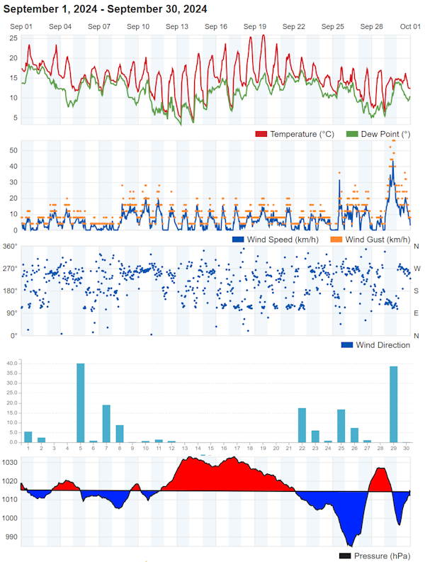
For a chart sequence for September click here
In terms of statistics:
The temperature for the month averaged close to 15 Celsius, marginally below the long term average (LTA). The warmest day was the 19th when temperatures widely reached 23 to 25 Celsius. Around the district many places had 6 to 14 days when afternoon temperatures exceeded 20 Celsius and a few locations had 1 or 2 days when 25 Celsius was reached. The coldest morning was on the 13th when the temperature dropped to between 4 and 7 Celsius, although Netherton dipped to almost 1 Celsius for that one morning. Most areas were frost free although the Netherton area was cold enough during the 12th to 14th for a touch of ground frost.
Rainfall totals in the Teignmouth and Dawlish area ranged from 140 to 170mm, well above the average of almost 60mm. There were 12 to 14 days with 1mm or more of rain which compares to an average of about 8 days, 5 days with 10mm or more (average 2 or 3 days) and 2 days with 20mm or more. Interestingly there where about the same number of dry days (12 to 14) as rain days (1mm or more).
There main windy period was on the 29th when south later southwest gales swept across the district.
Sunshine estimated at around 130 hours was below the average of 161 hours.
The sea temperature at the Dawlish wave buoy fell to 16 Celsius by the end of the month. The buoy recorded maximum wave heights of just over five metres on the 29th.
In summary, September 2024 was cloudier, very slightly cooler and much wetter than average.
When shown * estimates were made using reports from nearby sites in order to calculate missing data. Grass frost estimates use air temp below 4C
Exminster. Missing
Dawlish inland.
Average temp 14.8C. Air frost 0 days. Ground frost possible 0 days. Highest 25C on 19th. Lowest 4.1C morning of 13th.
12 days with 20C or more. 2 days with 25C or more.
Total rain 160mm. 13 dry days, 13 days with 1mm or more, 5 days 10mm or more, 2 days 20mm or more. Wettest day 40mm 5th .
Digital sun 165.5 hours (correction factor 0.8) = 132.4 hours.
Teignmouth Den. 101024 MAx missing from 17th
Mean temperature *16.5C (LTA 15.2C). Average Max *18.2C (LTA 18.6C). Highest *22C on 19th. Average Min 8.8*C (LTA 11.7C). Lowest 3C on 13th. Air frost 0. (Average 0). Potential 3 ground frosts
5 days with 20C or more. 0 days with 25C or more.
Total rain 168.4*mm (LTA 57.5mm). 13 dry days (LTA 17), 12 days with 1mm or more (LTA 8). Wettest day 43.9mm on the 29th 0900 to 0900 hours next day. 5 days with >= 10mm (LTA 2 or 3). 3 days with >= 20mm.
Total sun *118.1 hours (LTA 161 hours).
Teignmouth Inland.
Average temp 15.1C. Air frost 0 days. Ground frost possible 0 days. Highest 23.5C on 19th. Lowest 5.6C morning of 13th.
7 days with 20C or more. 0 days with 25C or more.
Total rain 155mm. 12 dry days, 13 days, with 1mm or more, 5 days 10mm or more, 2 days 20mm or more. Wettest day 42mm 29th.
Digital sun 167.7 hours (correction factor 0.8) = 134.6 hours.
Bitten Park.
Average temp 15.3C. Air frost 0days. Ground frost possible 0 days. Highest 14.7C on 19th. Lowest 6.2C morning of 13th.
12 days with 20C or more. 0 days with 25C or more.
Total rain 164.8mm. 13 dry days, 11 days with 1 mm or more, 5 days 10mm or more, 2 days 20mm or more. Wettest day 42.4mm on 5th.
Netherton.
Average temp 14C. Air frost 0days. Ground frost possible 3 days. Highest 24.1C on 19th. Lowest 1.3C morning of 13th.
8 days with 20C or more. 0 days with 25C or more.
Total rain 164.8mm. 12 dry days, 12 days with 1mm or more, 5 days 10mm or more, 2 days 20mm or more. Wettest day 52.9mm 29th .
Digital sun 172.5 hours (correction factor 0.8) = 138 hours.
Weather Summary SUMMER 2024
***
In summary, Summer 2024 was average. Temperature, Rainfall and Sunshine for the season was near or marginally below the long term average. The number of dry days was slightly above the average.
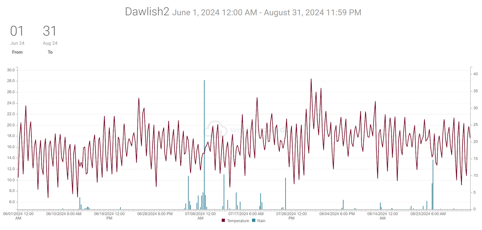
When shown * estimates were made using reports from nearby sites in order to calculate missing data. Grass frost estimates use air temp below 4C
Dawlish inland.
Average temp 16.6C. 70 days with 20C or more. 8 days with 25C or more.
Total rain 152mm. 60 dry days, 21 days with 1mm or more, 4 days 10mm or more, 2 days 20mm or more.
Digital sun 620 hours.
Teignmouth Den. *50% data missing estimated*
Mean temperature 15.7C (LTA 16.6C). Average Max 20.4C (LTA 20.2C). Average Min 10.9C (LTA 13.C).
54 days with 20C or more. 5 days with 25C or more.
Total rain 149.7mm (LTA 156mm). 70 dry days(LTA 54), 20 days with 1mm or more (LTA 23). 4 day with >= 10mm (LTA 5). 2 days with >= 20mm.
Total sun 678.9 hours (LTA 648 hours).
Teignmouth Inland.
Average temp 17C. 65 days with 20C or more. 6 days with 25C or more.
Total rain 140.5mm. 59 dry days, 19 days with 1mm or more, 4 days 10mm or more, 2 days 20mm or more.
Digital sun 643 hours.
Netherton.
Average temp 16.1C. 74 days with 20C or more. 5 days with 25C or more.
Total rain 145.8mm. 62 dry days, 20 days with 1mm or more, 4 days 10mm or more, 2 days 20mm or more.
Digital sun 655 hours.
Weather Summary August 2024 010924
Despite a drier than average August the weather during the month was slightly unsettled as a series of weather systems crossed the area. There were only fairly short-lived spells of high pressure. The warmest day at the start of the month was in a slack low-pressure area with light winds and a residue of very warm air. For most of the month the main low-pressure centres were mostly near the northwest of the UK although low pressure got nearer on the 8th/9th when it became quite windy for a time. The other period when low pressure significantly affected the district was between the 22nd and 25th when it was also quite windy. During the 24th a waving cold front became slow moving near the south coast of England and combined with a trough moving in from the Atlantic to produce around an inch of rain across many parts of the district.
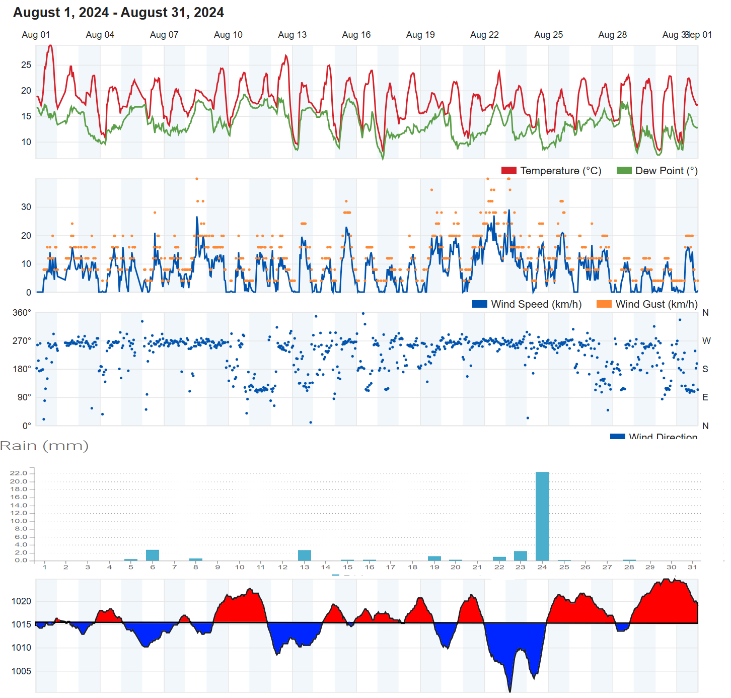
In terms of statistics:
The temperature for the month averaged out between 17.5 and 18.3 Celsius across the district, which was marginally above the long-term average. The top temperature for the month, ranged from 27 to 32 Celsius on the 1st of August. There were only a few days when the daytime temperature did not reach 20 Celsius and 1 to 6 days with 25 Celsius. Most places did not reach 30 Celius but a few sheltered locations did reach 30 Celius on a few occasions. The lowest temperature for the month was at Netherton which recorded 5 C Celsius on the 17th. More typically the lowest temperatures during the month ranged between 7 and 10 Celsius. This occurred mostly on the 17th but in a few places on the 30th.
Rainfall totals in the Teignmouth and Dawlish area were typically between about 35 and 35 mm which compares to an August average around 60mm. The only really wet day was on the 24th when between 18 and 25mm was recorded. The number of wet days, was between 3 and 6 days the average is 8 or 9 days and the number of day days was between 17 and 26 days (average about 16). There was only 1 days with 10mm or more in a day and the same day with 20mm or more in many areas.
There were a few windy spells, firstly on the 8/9th but more generally 22nd to25th.
Sunshine was estimated to be around 190 to 200 hours, which was near or slightly below the long-term average of 200 hours.
The sea temperature at the Dawlish wave buoy was around 18 or 19 Celsius throughout the month.
In summary, August 2024: Drier than average with both lower rainfall totals and increased number of dry days. Temperature marginally above average and sunshine near or a little below average.
When shown * estimates were made using reports from nearby sites in order to calculate missing data. Grass frost estimates use air temp below 4C
Kenton.
Average temp 17.7C. Highest 27.9C on 1st. Lowest 7.4C morning of 17th.
31days with 20C or more. 8 days with 25C or more.
Total rain 29.7mm. 26 dry days, 3 days with 1mm or more, 1 day 10mm or more, 1 days 20mm or more. Wettest day 24.6mm 24th.
Digital sun 257 hours (correction factor 0.7) = 180 hours.
Dawlish inland.
Average temp 17.6. Highest 28.8C on 1st. Lowest 7.6C morning of 17th.
29 days with 20C or more. 2 days with 25C or more.
Total rain 35mm. 18 dry days, 6 days with 1mm or more, 1 days 10mm or more, 1 days 20mm or more. Wettest day 22.4mm 24th .
Digital sun 261 hours (correction factor 0.7) = 183 hours.
Teignmouth Den.
Mean temperature 16.4C (LTA 17.3*C). Average Max 21.3C (LTA 20.8C). Highest 27C on 1st. Average Min 11.4C (LTA 13.7C). Lowest 7C on 17th.
27 days with 20C or more. 2 days with 25C or more.
Total rain 32mm (LTA 58mm). 25 dry days, 5 days with 1mm or more (LTA *). Wettest day 23.5mm on the 23rd 0900 to 0900 hours next day. 1 day with >= 10mm. 1 days with >= 20mm.
Total sun 225 hours (LTA 205 hours).
Teignmouth Inland.
Average temp 17.9C. Highest 28.2C on 1st. Lowest 9.7C morning of 30th.
29 days with 20C or more. 3 days with 25C or more.
Total rain 31mm . 18 dry days, 6 days, with 1mm or more, 1 days 10mm or more, 1 days 20mm or more. Wettest day 21mm 24th .
Digital sun 275 hours (correction factor 0.7) = 193 hours.
Bitten Park.
Average temp 18.6C. Highest 31.9C on 1st. Lowest 10.1C morning of 30th.
31 days with 20C or more. 4 days with 25C or more.
Total rain 30.8mm. 25 dry days, 3 days with 1 mm or more, 1 days 10mm or more, 1 days 20mm or more. Wettest day 25.2 on 24th.
Netherton.
Average temp 17.1C. Highest 27.8C on 1st. Lowest 5.3C morning of 17th.
27 days with 20C or more. 1 days with 25C or more.
Total rain 33.2mm. 19 dry days, 7 days with 1mm or more, 1 days 10mm or more, 1 days 20mm or more. Wettest day 20mm 24th .
Digital sun 282 hours (correction factor 0.7) = 197 hours.
Weather Summary July 2024 010824
Overall, a fairly changeable month which improved for the first week of the School holidays at the end of July. There was a promising start to July with a weak ridge and pleasant temperatures despite a chilly NW breeze. On the 4th and 5th an Atlantic wave depression moved quickly east across the south of England stating the wettest period of the month. A further low-pressure system and associated fronts moved over SW England on the 8th bring a truly wet and miserable day with 40 to 50mm of rain, almost the average for July in one day. The system moved away on the 9th but despite a weak ridge of higher pressure starting to form just west of the UK, further showery rain occurred mainly on the 12th and 13th. Yet another, fairly shallow, low pressure area moved across SW England to bring further rain on the 15th and 16th. High pressure over France then brought a few dry days before some rain on the 20th associated with a weakening frontal trough. Further shallow low pressure areas cross the south of England on the 22nd/23rd but most parts of the Dawlish areas remained dry until a further Atlantic system arrived on the 24th/25th. The month ended with mostly high pressure nearby resulting in light winds and sunshine and some quite hot temperatures.
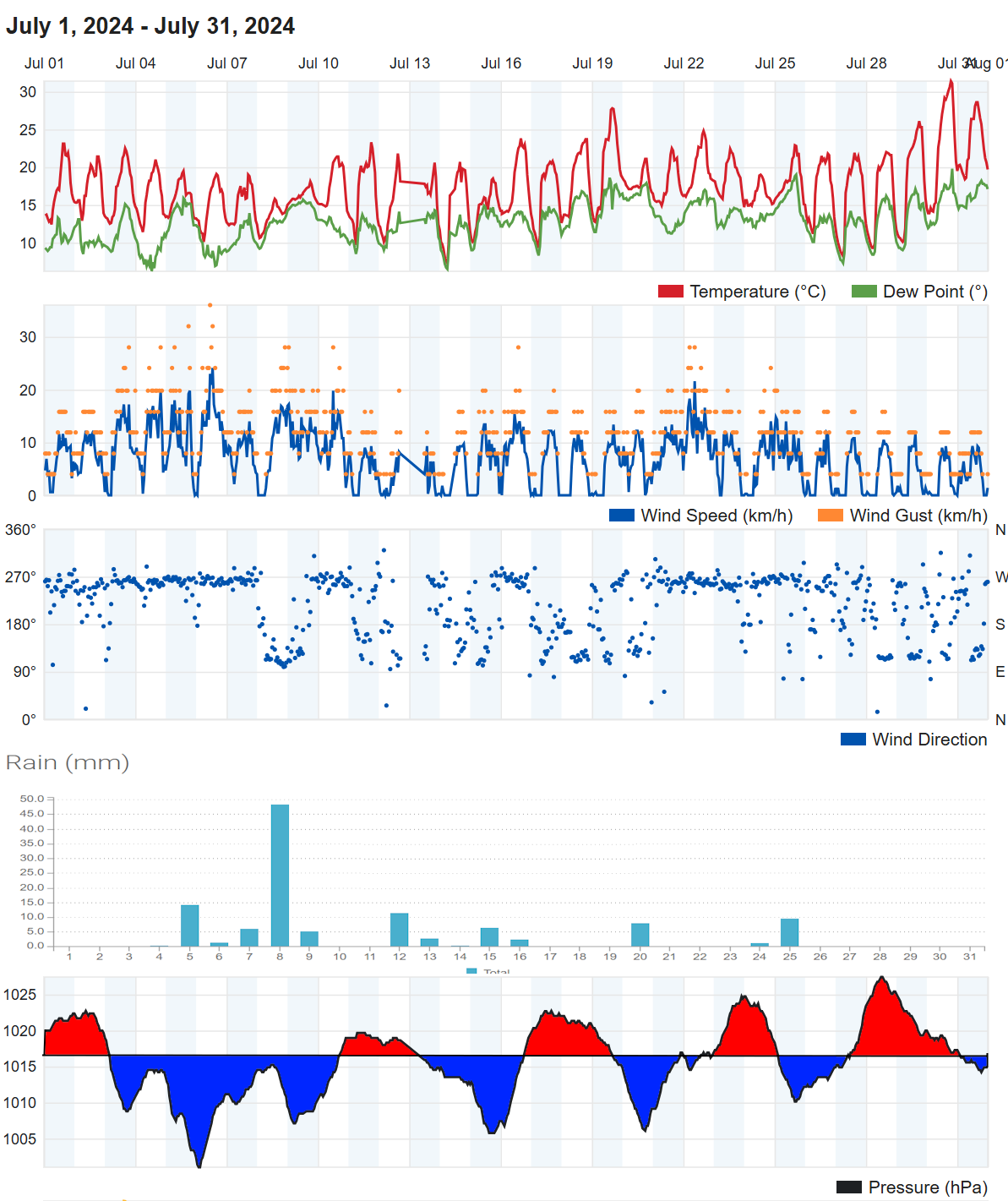
For a chart sequence for July click here
In terms of statistics:
The temperature for the month averaged out near 17 Celsius across the district, which very close to the long-term average albeit slightly below (LTA 17.4C). The top temperature for the month, ranging across the district from 29 to 32 Celsius, occurred on the 30th. There were 16 and 28 days when the temperature reached 20 Celsius, 2 to 5 days with 25 Celius and one or two days at the end of the month when inland areas reached 30 Celsius. The lowest temperature for the month between 6 and 10 Celsius occurred on the 14th across the district.
Rainfall totals in the Teignmouth and Dawlish area were typically between about 90 and 110mm which compares to a July average of 40 to 50mm. The wettest day was the 8th with between 40 and 50mm recorded. It is not a surprise therefore that the number of wet days, around 12, was above the 30-year average of 7 days. What is perhaps more surprising is that the number of day days was close to the average of about 19 days. There were around 3 days with 10mm or more in a day and mostly 1 day with 20mm or more.
There were some windy spells early in the month especially the 8th/9th.
Sunshine was estimated to be around 190 to 200 hours, which was below the long-term average of 220 hours.
The sea temperature at the Dawlish wave buoy rose from 16 Celsius at the start of the month to vary between 18 and 20 Celsius over the last few days of July.
In summary, July 2024 compared to average, the temperature was very slightly lower, there was less sunshine and rainfall was around double. Despite a high rainfall total the number of dry days was about average.
When shown * estimates were made using reports from nearby sites in order to calculate missing data. Grass frost estimates use air temp below 4C
Kenton.
Average temp 17C. Highest 31.5C on 30th. Lowest 7C morning of 14th.
28 days with 20C or more. 5 days with 25C or more.
Total rain 110mm. 19 dry days, 11 days with 1mm or more, 3 days 10mm or more, 2 days 20mm or more. Wettest day 41 on 8th.
Dawlish inland.
Average temp 16.8C. Highest 31C on 30th. Lowest 7C morning of 14th.
24 days with 20C or more. 4 days with 25C or more.
Total rain 101mm. 19 dry days, 11 days with 1mm or more, 3 days 10mm or more, 1 days 20mm or more. Wettest day 43mm 8th .
Digital sun 275 hours (correction factor 0.7) = 193 hours.
Teignmouth Den*.
Mean temperature 16.1C (LTA 17.3C). Average Max 20.4C (LTA 21C). Highest 28.3C on 30th. Average Min 11.8C (LTA 13.7C). Lowest 5.7C on 14th.
18 days with 20C or more. 3 days with 25C or more.
Total rain 111*mm (LTA 46mm). 18 dry days, 13 days with 1mm or more (LTA 7). Wettest day 42*mm on the 8th 0900 to 0900 hours next day. 3 day with >= 10mm. 1 days with >= 20mm.
Total sun *210 hours (LTA 225 hours).
Teignmouth Inland.
Average temp 17.2C. Highest 28.3C on 30th. Lowest 9.1C morning of 14th.
21 days with 20C or more. 3 days with 25C or more.
Total rain 100mm. 17 dry days, 11 days, with 1mm or more, 3 days 10mm or more, 1 days 20mm or more. Wettest day 40mm on 8th .
Digital sun 295 hours (correction factor 0.7) = 206 hours.
Bitten Park.
Average temp 17.5C. Highest 32.5C on 30th. Lowest 9.2C morning of 14th.
26 days with 20C or more. 5 days with 25C or more.
Rain missing.
Netherton.
Average temp 16.4C. Highest 28.6C on 30th. Lowest 5.7C morning of 14th.
22 days with 20C or more. 2 days with 25C or more.
Total rain 101.7mm. 19 dry days, 10 days with 1mm or more, 3 days 10mm or more, 1 days 20mm or more. Wettest day 49.8mm on 8th.
Digital sun 292hours (correction factor 0.7) = 204 hours.
Weather Summary June 2024 updated 3rd July. 6 July 2024
Most of the month could be seen as being close enough to High Pressure systems, mostly positioned to the SW or W of the UK, which led to an unusually dry month. Typically, a dry month might be associated with a warm spell but in fact temperatures ended up close to average despite over half the month recording maximum temperature of 20 Celsius or more. The were some spells of lower pressure on the 4th, 5th 13th to 18th, 21st, 25th to 27th and on the 29th but these brought very little rain. The wettest and windiest period was the 13th to 15th but even the wettest day of the month (13th) only recorded 3 to 6mm of rain across the district.
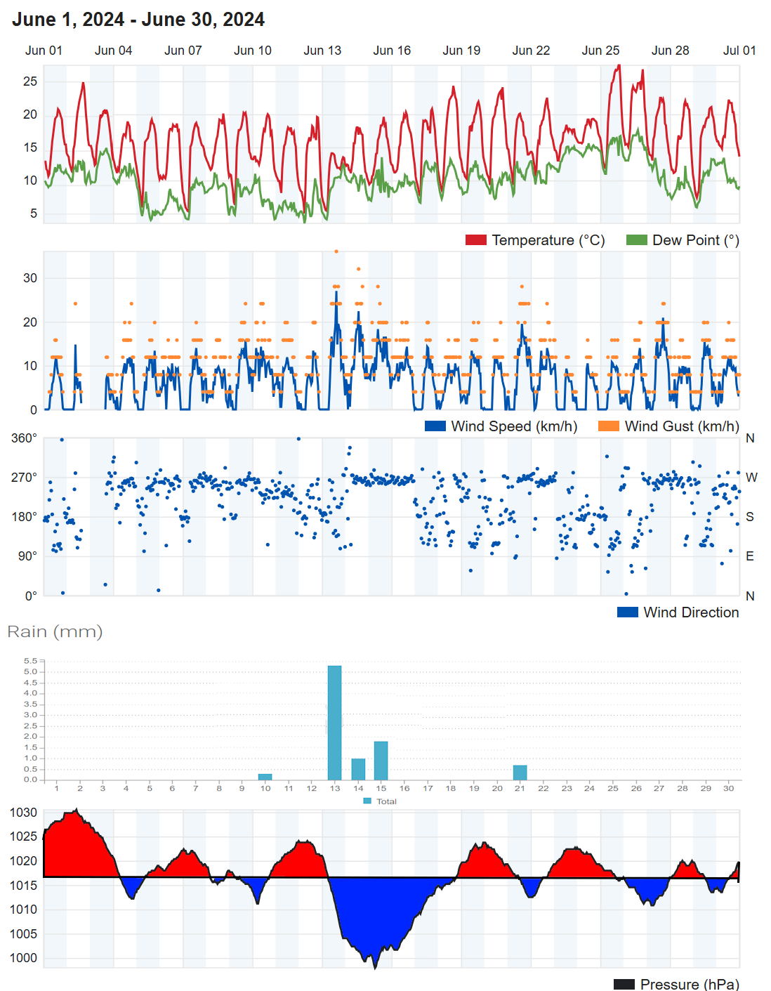
For a chart sequence for June click here
In terms of statistics:
The temperature for the month averaged out between 15 and 16 Celsius across the district, which very close to the long-term average. The top temperature for the month, typically 24 to 26 Celsius, occurred on the 25th but in a few places on the 26th but a few sheltered parts of Teignmouth, Holcombe, Netherton, Kenton and Exminster recorded a temperature around 30 Celsius. The lowest temperature for the month between 4 and 7 Celsius occurred on the 4th in area west from Holcombe and on the 7th elsewhere.
Rainfall totals in the Teignmouth and Dawlish were typically between 5 and 10mm. The average rainfall for June is around 55mm. The wettest day was the 13th with between 3 and 6mm recorded. There was around 25 dry days (typically 19), 2 or 3 days with 1mm or more (typically 8), no days with 10mm or more (typically 1 or 2). The only wet days were the 13th to 15th.
There only windy period was on the 13th.
Sunshine was estimated to be around 244 hours, which was above the long-term average of 220 hours.
The sea temperature at the Dawlish wave buoy rose from 14 Celsius to 16 Celsius by the end of the month having peaked at 18 Celsius on the 25 and 26th.
In summary, June 2024 had near average temperature but was much drier and slightly sunnier than average.
When shown * estimates were made using reports from nearby sites in order to calculate missing data. Grass frost estimates use air temp below 4C
Exminster.
Average temp 16.8C. Air frost 0days. Ground frost possible 0 days. Highest 31.6C on 25th. Lowest 5.6C morning of 5th.
27days with 20C or more. 17 days with 25C or more, 1 day with 30C or more.
Total rain 9.9mm. 23dry days, 3 days with 1mm or more, 0 days 10mm or more, 0 days 20mm or more. Wettest day 4.3mm on 13th.
Dawlish inland.
Average temp 15.4C. Air frost 0days. Ground frost possible 0 days. Highest 26C on 25th. Lowest 5C morning of 12th.
16 days with 20C or more. 3 days with 25C or more.
Total rain 9.1mm. 25 dry days, 3 days with 1mm or more, 0 days 10mm or more, 0 days 20mm or more. Wettest day 5.3mm 13th .
Digital sun 304.5 hours (correction factor 0.8) = 244 hours.
Teignmouth Den.*
Mean temperature 14.5C (LTA 15.2C). Average Max 19.4C (LTA 18.7C). Highest 23.8C on 25th. Average Min 9.6C (LTA 11.6C). Lowest 6.6C on 5th. Air frost 0. (Average **). Potential 0 ground frosts
12 days with 20C or more. 0 days with 25C or more.
Total rain 6.5mm (LTA 50.5mm). 27 dry days, 2 days with 1mm or more (LTA 8). Wettest day 5 mm on the 13th 0900 to 0900 hours next day. 0 day with >= 10mm. 0 days with >= 20mm.
Total sun 244* hours (LTA 222* hours).
Teignmouth Inland.
Average temp 15.8C. Air frost 0days. Ground frost possible 0 days. Highest 24.5C on 25th. Lowest 6.9C morning of 7th.
15 days with 20C or more. 0 days with 25C or more.
Total rain 9.5mm. 24 dry days, 2 days, with 1mm or more, 0 days 10mm or more, 0 days 20mm or more. Wettest day 5mm 13th .
Digital sun 348.6 hours (correction factor 0.7) = 244 hours.
Bitten Park.
Average temp 16.4C. Air frost 0days. Ground frost possible 0 days. Highest 29.5C on 25th. Lowest 7.7C morning of 7th.
Netherton.
Average temp 14.8C. Air frost 0days. Ground frost possible 0 days. Highest 26.9C on 26th. Lowest 3.8C morning of 7th.
13 days with 20C or more. 2 days with 25C or more.
Total rain 10.9mm. 24 dry days, 3 days with 1mm or more, 0 days 10mm or more, 0 days 20mm or more. Wettest day 6.1mm 13th .
Digital sun 318 hours (correction factor 0.8) = 254 hours.
Weather Summary Spring 2024 040624
In summary, Spring was milder, wetter and cloudier than average
When shown * estimates were made using reports from nearby sites in order to calculate missing data. Grass frost estimates use air temp below 4C
Dawlish inland.
Average temp 10.9C. Air frost 0 days. Ground frost possible 1 day.
11 days with 20C or more. 0 days with 25C or more.
Total rain 327.7mm. 36 dry days, 46 days with 1mm or more, 11 days 10mm or more, 3 days 20mm or more.
Digital sun 452 hours (corrected).
*Teignmouth Den.*updated 060724*
Mean temperature 11C (LTA 9.9C). Average Max 14.5C (LTA 13.1C). Average Min 7.5C (LTA 6.7C). Air frost 0. (Average 1.8). Potential 0 ground frosts
2 days with 20C or more. 0 days with 25C or more.
Total rain 348mm (LTA 186.6mm). 36 dry days (LTA 48), 43 days with 1mm or more (LTA 29.8). 10 days with >= 10mm (LTA 8 days). 6 days with >= 20mm.
Total sun 470 hours (LTA 526.4 hours).
Netherton.
Average temp 10.6C. Air frost 6 days. Ground frost possible 22 days.
6 days with 20C or more. 0 days with 25C or more.
Total rain 409.8mm, 29 dry days, 45 days with 1mm or more, 15 days 10mm or more, 4 days 20mm or more. Wettest day **mm **th .
Digital sun 462 hours (corrected).
Weather Summary May 2024 040624 updated 060724
The driest period of the month from the 7th to 12th was associated by a period of High pressure. High pressure made fleeting visits across SW England around the 23rd and 31st otherwise Low pressure dominated the weather patterns through the month. The most active low pressure systems were on the 2nd and 13th with these two days producing over half of the months rain. The period 13th to 15th was rather windy and also noticeably cool as far as daytime temperatures were concerned. Many of the dry days during periods of low pressure were a matter of luck with showers or patchy rain not far away. Despite the wetter than average month as far as rain totals are concerned there was about the same number of dry days in May as normal and there were quite a few days with afternoon temperature of twenty Celsius or more.
For a chart sequence for May click here
In terms of statistics:
The temperature for the month averaged out between 13.5 and 14 Celsius across the district, which was a degree or so above the long-term average. The top temperature for the month, typically 22 to 24 Celsius occurred on the 12th in most places but in others on the 31st and a few in Teignmouth on the 18th. The coldest morning occurred on the 4th with a low of 1.5C in a few sheltered valleys but more typically between 4 and 6 Celsius. A few colder spots may have had a touch of ground frost on the 4th but generally the month was frost free.
Rainfall totals in the Teignmouth and Dawlish were typically between 80 and 100mm. The average rainfall for May is just below 60mm. The wettest days were the 2nd and 13th with between 20 and 30mm, in some places the2nd was the wettest day and in others the 13th. There was around 17 dry days (typically 17), 10-12 days with 1mm or more (typically 9), 2 to 4 days with 10mm or more (typically 3) and 1 or 2 days with over 20mm of rain. The main wet days were 1st, 2nd , 5th, 6th , 13th , 18th , 22nd and 25th to 30th.
There were several windy periods including the 12th to 16th and 27th to 30th.
Sunshine was estimated to be around 200 hours, not far from the long-term average.
The sea temperature at the Dawlish wave buoy rose from 12 Celsius to 14 Celsius by the end of the month having peaked at 16 Celsius on the 22nd.
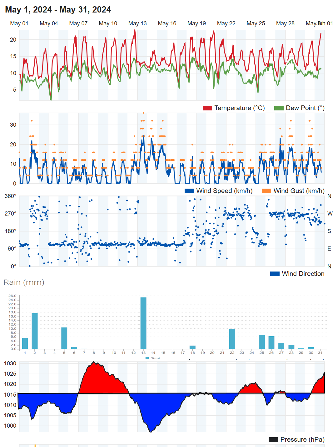
In summary, May 2024 was milder and wetter than average but with near average sunshine
When shown * estimates were made using reports from nearby sites in order to calculate missing data. Grass frost estimates use air temp below 4C
Exminster.
Average temp 14.6C. Air frost 0 days. Ground frost possible 1 day. Highest 26.3C on 31st. Lowest 3.2C morning of 4th.
23 days with 20C or more. 2 days with 25C or more.
Total rain 95mm. 16 dry days, 10 days with 1mm or more, 2 days 10mm or more, 2 days 20mm or more. Wettest day 30.2 on 2nd 26.7 13th.
Dawlish inland.
Average temp 13.6C. Air frost 0days. Ground frost possible 1 day. Highest 22.8C on 12th. Lowest 1.5C morning of 4th.
10 days with 20C or more. 0 days with 25C or more.
Total rain 93mm. 18 dry days, 12 days with 1mm or more, 3 days 10mm or more, 2 days 20mm or more. Wettest day 24.9mm 2nd 21.6 13th.
Digital sun 275 hours (correction factor 0.8) = 220 hours.
Teignmouth Den. added when available several missing days
Mean temperature 13.1C (LTA 12.5C). Average Max 17.1C (LTA 16C). Highest 20.8C on 12th. Average Min 9C (LTA 9C). Lowest 5C on 4th. Air frost 0. (Average 0). Potential 0 ground frosts
2 days with 20C or more. 0 days with 25C or more.
Total rain 91.3mm (LTA 59mm). 14 dry days(LTA 17), 14days with 1mm or more (LTA 9). Wettest day 23.2*mm on the 13th 0900 to 0900 hours next day. 3 day with >= 10mm (LTA 3). 2 days with >= 20mm.
Total sun 220* hours (LTA 216 hours).
Teignmouth Inland.
Average temp 14C. Air frost 0days. Ground frost possible 0 days. Highest 22C on 12th. Lowest 5C morning of 4th.
3 days with 20C or more. 0 days with 25C or more.
Total rain 95mm. 17 dry days, 11 days with 1mm or more, 4 days 10mm or more, 2 days 20mm or more. Wettest day 23mm 13th 22mm 2nd.
Digital sun 320 hours (correction factor 0.6) = 192 hours.
Bitten Park.
Average temp 14.2C. Air frost 0 days. Ground frost possible 0 days. Highest 24.8C on 18th. Lowest 4.8C morning of 4th.
* days with 20C or more. * days with 25C or more.
Total rain --some miising data --. Wettest day 25.6mm on 2nd.
Netherton.
Average temp 13C. Air frost 0days. Ground frost possible 2 days. Highest 22.4C on 12th. Lowest 1.9C morning of 4th.
6 days with 20C or more. 0 days with 25C or more.
Total rain 99.1mm. 14 dry days, 12 days with 1mm or more, 3 days 10mm or more, 2 days 20mm or more. Wettest day 26.1mm 2nd 26.4mm on 13th .
Digital sun 283 hours (correction factor 0.7) = 198 hours.
Weather Summary April 2024 010524**
Low pressure dominated the weather patterns for the first and last week of April with higher pressure for the middle two weeks of the month. Initially low pressure was slow moving and fairly flabby bringing periods of at times heavy rain. A deeper low, named storm Kathleen by the Irish Met Service, brought a windier spell for SW England for the 5th, 6th and 7th. A fairly deep low moved across Devon on the 8th again with some strong winds and this depression was named storm Pierrick by the French Met Service. From the 11th a ridge of higher pressure developed over and to the south of England and a fairly strong but mild strong south-westerly wind saw the cloud breaking to allow some sunny spells with temperatures rising to around 20 Celsius in the period 11th to 13th. A cold front on the 14th brought temperature down again. The showery rain and strong NW winds on the 15th and 16th was caused by low pressure moving SE over the North Sea and this too was named by the Frech Met service as storm Renata although there was little impact across the SW of England. High pressure developed again with another largely dry period until the 26th. Low pressure again took charge through to the end of the month producing periods of heavy and possibly thundery outbreak of rain. The heaviest during this period was over the more western parts of Teign estuary.
In terms of statistics:
The temperature for the month averaged out between 10 and 11 Celsius across the district, which was half to one degree Celsius above the long-term average. The top temperature for the month, between 19 and 21 Celsius occurred on the 13th. The coldest mornings occurred between the 18th and 22nd in most places although in Teignmouth it was on the 1st of the month. Most places avoided a air frost with lowest temperatures between 1 and 4 Celsius although in the Netherton area the temperature dip just below freezing on the 18th. Inland parts of Dawlish as well as Netherton, Exminster and Kenton had at least few nights when a ground frost was possible.
Rainfall totals in the Teignmouth and Dawlish were typically between 70 and 90mm although two sites at Netherton recorded over 130mm. The average rainfall for April is around 60mm. The wettest days were the 2nd and 26th with between 15 and 20mm although the Netherton area recorded around 37mm on the 26th. There was around 13 dry days (typically 15), 11-14 days with 1mm or more (typically 10), 2 to 5 days with 10mm or more (typically 3) and in places 1 day with over 20mm of rain. The main wet days were 1st to 5th, 8th to 10th and 26th to 30th.
There were several windy periods including the 5th, 6th, 7th, 9th, 12th, 15th and 16th.
Sunshine was estimated to be around 140 hours, about three quarters of the long-term average.
The sea temperature at the Dawlish wave buoy slowly rose to almost 12 Celsius by the end of the month.
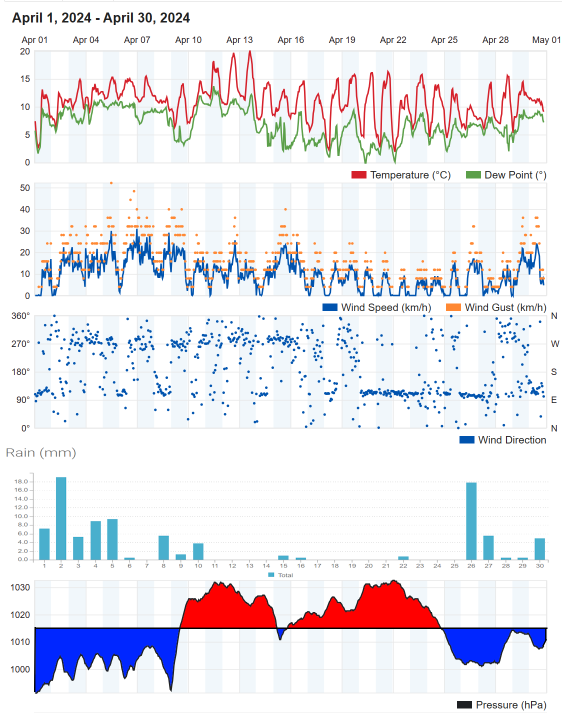
In summary, April 2024 was milder, wetter and cloudier than average.
When shown * estimates were made using reports from nearby sites in order to calculate missing data. Grass frost estimates use air temp below 4C
Exminster.
Average temp 10.9C. Air frost 0 days. Ground frost possible 6 days. Highest 26C on 13th. Lowest 1.9C morning of 21st.
4 days with 20C or more. 1 days with 25C or more.
Total rain 84mm. 13 dry days, 14 days with 1mm or more, 2 days 10mm or more, 0 days 20mm or more. Wettest day 14.7 on 2nd.
Kenton.
Average temp 10.4C. Air frost 0days. Ground frost possible 6 days. Highest 21C on 13th. Lowest 1.6C morning of 18th.
2 days with 20C or more. 0 days with 25C or more.
Total rain 89mm. 12 dry days, 13 days with 1mm or more, 2 days 10mm or more, 1 days 20mm or more. Wettest day 20.3mm 2nd.
Digital sun 199 hours (correction factor 0.7) = 139 hours.
Dawlish inland.
Average temp 10.6C. Air frost 0days. Ground frost possible 4 days. Highest 20C on 13th. Lowest 1.8C morning of 22nd.
1 days with 20C or more. 0 days with 25C or more.
Total rain 90mm. 13 dry days, 13 days with 1mm or more, 2 days 10mm or more, 0 days 20mm or more. Wettest day 19mm 2nd.
Digital sun 197 hours (correction factor 0.7) = 138 hours.
Teignmouth Den. added 270524 No sunshine records available
Mean temperature 10.8C (LTA 9.5C). Average Max 14C (LTA 13C). Highest 19C on 12th. Average Min 7.7C (LTA 6.1C). Lowest 1.8C on 1st. Air frost 0. (Average 0.4 days). Potential 1 ground frosts
0 days with 20C or more. 0 days with 25C or more.
Total rain 92.5mm (LTA 60mm). 14 dry days (LTA 15), 12 days with 1mm or more (LTA 10). Wettest day 22.8mm on the 27th 0900 to 0900 hours next day. 2 days with >= 10mm (LTA 2 to 4). 2 days with >= 20mm.
Total sun *150* hours (LTA 186 hours).
Teignmouth Inland.
Average temp 11C. Air frost 0days. Ground frost possible 0 days. Highest 20.1C on 13th. Lowest 4.3C morning of 1st.
1 days with 20C or more. 0* days with 25C or more.
Total rain 84mm. 14 dry days, 11 days, with 1mm or more, 2 days 10mm or more, 1 days 20mm or more. Wettest day 21mm 26th .
Digital sun 250 hours (correction factor 0.6) = 150 hours.
Bitten Park.
Average temp 11.2C. Air frost 0days. Ground frost possible 0 days. Highest 20.3C on 13th. Lowest 4.8C morning of 1st.
1 days with 20C or more. 0 days with 25C or more.
Total rain 78mm. 12dry days, 11days with 1 mm or more, 2 days 10mm or more, 1 days 20mm or more. Wettest day 25.2 on 26th.
Netherton.
Average temp 10.2C. Air frost 1day. Ground frost possible 8 days. Highest 18.1C on 12th. Lowest -0.3C morning of 18th.
0days with 20C or more. 0 days with 25C or more.
Total rain 132mm. 9 dry days, 12 days with 1mm or more, 5 days 10mm or more, 1 days 20mm or more. Wettest day 37.8mm pn 26th .
Digital sun 224 hours (correction factor 0.7) = 156 hours.
Weather Summary March 2024 02APR 2024
Despite low pressure and weather fronts, which brought cloud, rain and showers across SW England during the early part of the month, the air was cold enough and there were enough clear skies to allow for a touch of frost in many parts. Similarly, there was a touch of frost in places around the 27 and 28th despite this being the wettest part of the month in association with storm Nelson, (named by the Spanish Met Agency NB: Snow fell on Dartmoor during this period). For much of the month though temperatures were milder than average as low pressure to the west or SW of the UK brought cloudy skies and periods of rain. The very few completely dry 24-hour periods occurred during weak ridges between the 6th and 8th and 20 and 21st.
A chart sequence for March 2024 is available here
In terms of statistics:
The temperature for the month averaged out around 9 Celsius across the district, which is about one degree Celsius above the long-term average. The top temperature for the month, between 16 and 17 Celsius occurred on the 17th (although a few places saw similar values on the 20th or 21st). The coldest morning occurred on the 3rd (but in a few places on the 6th) when the temperature dropped to near freezing in many parts of the district and to as low as minus three Celsius in Netherton. Overall, there were between 6 and 11 nights when a ground frost was possible. Inland valleys had air frost on between 1 and 5 nights but many other places, including the coastal areas, escaped with no air frost recorded.
Rainfall totals in the Teignmouth and Dawlish area reached 120 to 150mm, roughly twice the longer-term average. The wettest day was the 27th when 22 to 29mm of rain was recorded. There was between 5 and 9 dry days (typically 16), 17 to 20 days with 1mm or more (typically 11), 2 to 5 days with 10mm or more (typically 2) and 1 days with over 20mm of rain. The main wet days were 1st 4th 9th 10th 27th and 28th.
There were several windy periods including the 1st, 5th, 19th, 28th and 29th the latter being associated with storm Nelson.
Sunshine was estimated to be around 95hours, about three quarters of the long-term average.
The sea temperature at the Dawlish wave buoy slowly rose from 10 to 11 Celsius during the month.
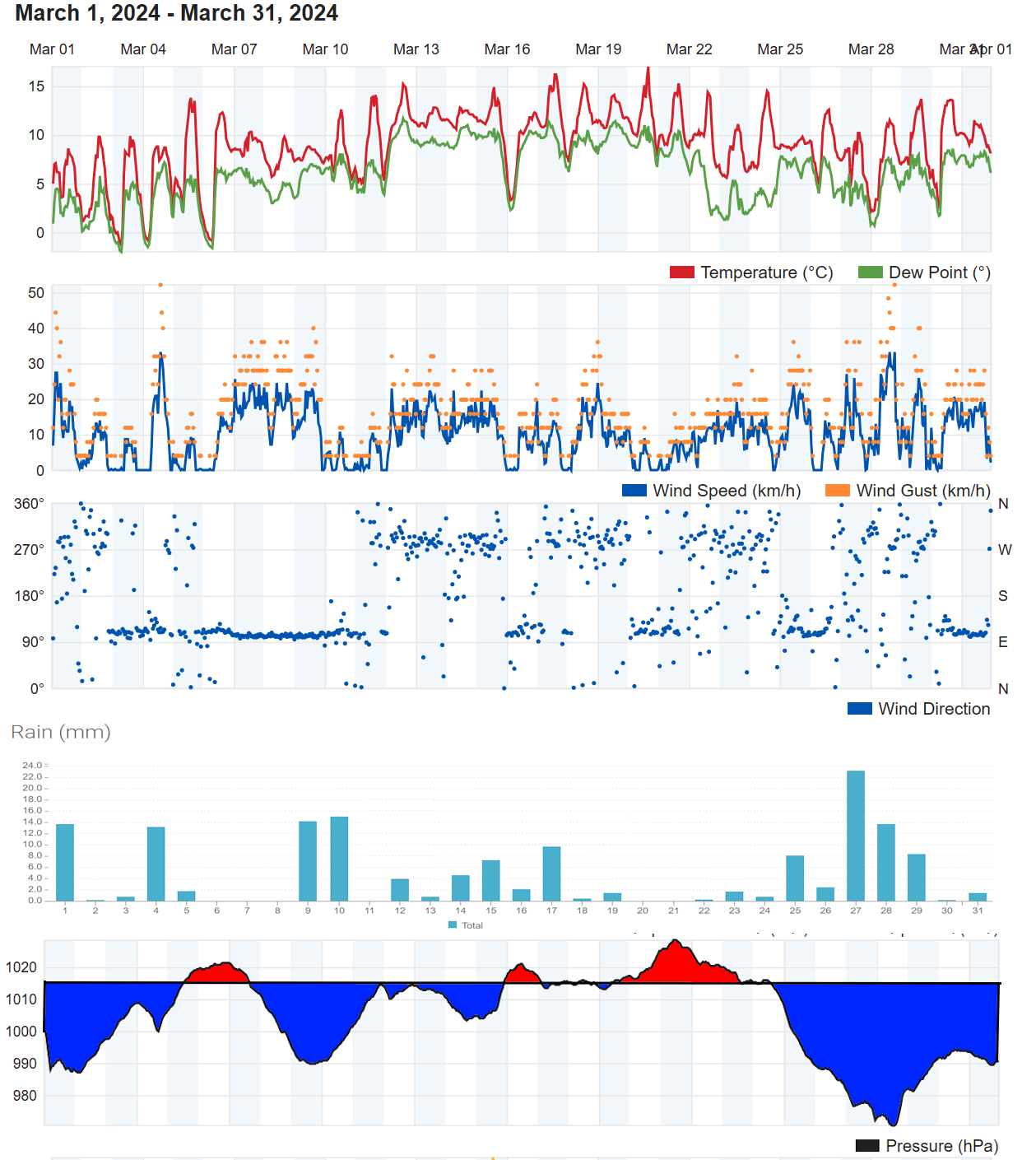
In summary, March 2024 was wetter, cloudier and milder than average, although the cold start to the month allowed above average frosts.
When shown * estimates were made using reports from nearby sites in order to calculate missing data. Grass frost estimates use air temp below 4C
Exminster.
Average temp 9C. Air frost 3days. Ground frost possible 9 days. Highest 20.7C on 17th. Lowest -1.6C morning of 3rd.
Total rain 119.4mm. 8 dry days, 16 days with 1mm or more, 4 days 10mm or more, 1 days 20mm or more. Wettest day * on *th.
Dawlish inland.
Average temp 8.8C. Air frost 3days. Ground frost possible 10 days. Highest 17C on 17/20th. Lowest -1C morning of 3rd.
Total rain 149mm. 6 dry days, 19 days with 1mm or more, 6 days 10mm or more, 1 day 20mm or more. Wettest day 24mm 27th .
Digital sun 134.1 hours (correction factor 0.7) = 94 hours.
Teignmouth Den.*some missing data and no sunshine data* added 070424
Mean temperature 9.1C (LTA 8C). Average Max 12.3*C (LTA 11C). Highest 15.8C on 17th. Average Min 5.9C (LTA 5C). Lowest -2.8C on 6th. Air frost 3 nights. (Average 1 or 2). Potential 9 ground frosts
Total rain 164.5mm (LTA 68mm). 8 dry days (LTA 16), 17 days with 1mm or more (LTA 11). Wettest day 29mm on the 27th 0900 to 0900 hours next day. 5 days with >= 10mm (LTA 2). 2 days with >= 20mm.
Total sun *100* hours (LTA 125 hours).
Teignmouth Inland.
Average temp 9.1C. Air frost 0days. Ground frost possible 8 days. Highest 16.9C on 17th. Lowest 0.2C morning of 6th.
Total rain 143.8mm. 5 dry days, 19 days with 1mm or more, 5 days 10mm or more, 1 days 20mm or more. Wettest day 29mm 27th .
Digital sun 174 hours (correction factor 0.6) = 105 hours.
Bitten Park.
Average temp 9.3C. Air frost 0days. Ground frost possible 8 days. Highest 16.7C on 17th. Lowest 0.8C morning of 3rd and 6th.
Total rain 119.6mm. 8 dry days, 13 days with 1 mm or more, 5 days 10mm or more, 1 days 20mm or more. Wettest day 27.6 on 27th.
Netherton.
Average temp 8.5C. Air frost 5days. Ground frost possible 12 days. Highest 16.1C on 21st. Lowest -2.9C morning of 6th.
Total rain 178.9mm. 6 dry days, 21 days with 1mm or more, 7 days 10mm or more, 1 day 20mm or more. Wettest day 23.9mm 27th .
Digital sun 155.9 hours (correction factor 0.7) = 108 hours.
Weather Summary Winter 2023/2024 DJF 3 March 2024
Summary - The winter was milder, cloudier and much wetter than average.
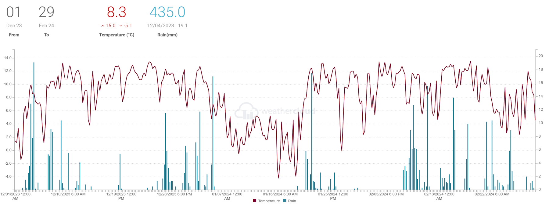
When shown * estimates were made using reports from nearby sites in order to calculate missing data. Grass frost estimates use air temp below 4C
Teignmouth Den*uodated 070324.
Mean temperature 8.1*C (LTA 6.7C). Average Max 11.4*C (LTA 9.4C). Average Min 5*C (LTA 4C). Air frost 11*. (Average 12). Potential 29* ground frosts
Total rain 470.8*mm (LTA 269.9mm). 38* dry days (LTA 40.5), 47* days with 1mm or more (LTA 36). 15 day with >= 10mm (LTA 9.5). 7* days with >= 20mm.
Total sun *183 hours (LTA 207.4 hours).
Dawlish inland.
Average temp 7.9C. Air frost 13days. Ground frost possible 35 days.
Total rain 433.6mm. 29 dry days, 55 days with 1mm or more, 18 days 10mm or more, 7 days 20mm or more.
Digital sun corrected = 156.6 hours.
Netherton.
Average temp 7.9C. Air frost 23days. Ground frost possible 41days.
Total rain 505mm. 36 dry days, 46 days with 1mm or more, 20 days 10mm or more, 9 days 20mm or more.
Corrected digital sun 170.9 hours.
Weather Summary February 2024 010324
For the first five days of the month high pressure over Biscay was close enough to keep the district dry with quite mild temperatures despite an increasing westerly wind. The dry spell ended on the 6th as a cold front moved south over the district to be followed by a series of fronts as low pressure moved in from the Atlantic. This produced the wettest period of the month as the low pressure continued to move east to be centred over the district by the 11th. After a dry day on the 12th strong SW winds brought further Atlantic weather fronts and rain across the district with some further heavy rain on the 15th. A slightly drier spell followed, chiefly on the 18th and 19th before the return of unsettled weather types. In particular low pressure on the 25th/26th passed just south of the district and produced east or northeast gales as well as some heavy rain. There was a brief respite on the 27th due to a weak ridge of higher pressure before the month ended with further rain.
In terms of statistics:
The temperature for the month averaged out around 9.5 Celsius across the district, which is about 2.5 Celsius above the long-term average. The top temperature for the month occurred during an especially mild period between the 15th and 19th reaching around 15 Celsius for most and up to 16 Celsius in a few places. The coldest mornings occurred between the 25th and 27th when the temperature dropped to 1 or 2 Celsius for most parts but near or just below freezing in a few inland areas. Most places avoided an air frost although areas away from the coast got close to freezing during this period and Netherton managed 4 nights with an air frost.
Rainfall totals in the Teignmouth and Dawlish area where two to three times the average with totals in the range 160 and 180 mm although the Netherton area recorded just over 200mm. The wettest day was the 8th when 25 to 30mm of rain was recorded. There was around 9 dry days (typically 14), 18 days with 1mm or more, 6 to 9 days with 10mm or more and in most places 2 days with over 20mm of rain. In addition to the 8th the other wet day was the 15th.
There were several windy periods including the 6, 8, 10th and 25th.
Sunshine estimated at around 65hours, about two thirds of the long-term average of 64 hours.
The sea temperature at the Dawlish wave buoy was close to 10 Celsius during the month.
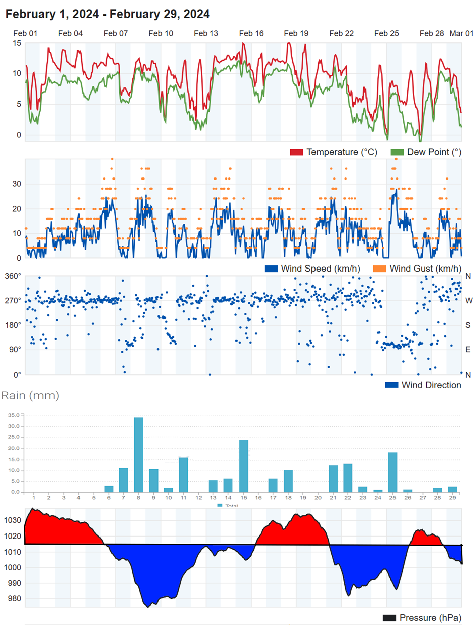
In summary,
February 2024 was exceptionally mild. It was wet with over double the average rainfall total and almost twice the number of wet days. Not surprisingly sunshine hours were much reduced.
When shown * estimates were made using reports from nearby sites in order to calculate missing data. Grass frost estimates use air temp below 4C
Exminster.
Average temp 9.3C. Air frost 1days. Ground frost possible 8 days. Highest 17.9C on 15th. Lowest -0.1C morning of 27th.
Total rain 146.8mm. 9 dry days, 18 days with 1mm or more, 5 days 10mm or more, 2 days 20mm or more. Wettest day 25.2mm on 8th.
Dawlish inland.
Average temp 9.2C. Air frost 2days. Ground frost possible 10 days. Highest 15C on 18th. Lowest -0.4C morning of 27th.
Total rain 182mm. 10 dry days, 19 days with 1mm or more, 8 days 10mm or more, 2 days 20mm or more. Wettest day 34mm 8th .
Digital sun 65.1 hours (correction factor 1) = 65.1 hours.
Teignmouth Den. updated 070324
Mean temperature 9.4*C (LTA 6.4C). Average Max 12.9*C (LTA 9.1C). Average Min 6.5*C (LTA 3.7C). Air frost *0. (Average 4). Potential 3* ground frosts
Total rain 190.4**mm (LTA 72mm). *9 dry days (LTA 14 days), 18 days with 1mm or more (LTA 10). 8* day with >= 10mm (LTA 3). *4 days with >= 20mm.
Total sun *67 hours (LTA 84 hours).
Teignmouth Inland.
Average temp 9.4C. Air frost 0days. Ground frost possible 6 days. Highest 15.6C on 18th. Lowest 1.3C morning of 27th.
Total rain 164.8mm. 8 dry days, 18 days with 1mm or more, 7 days 10mm or more, 2 days 20mm or more. Wettest day 28.7mm 8th .
Digital sun 96.9 hours (correction factor 0.7) = 67 hours.
Bitten Park.
Average temp 9.6C. Air frost 0days. Ground frost possible 6 days. Highest 16.3C on 15h. Lowest 1.5 morning of 27th.
Total rain 174mm. 9 dry days, 18 days with 1 mm or more, 10 days 10mm or more, 2 days 20mm or more. Wettest day 32mm on 8th.
Netherton.
Average temp 9C. Air frost 4 days. Ground frost possible 11 days. Highest 15.7C on 18th. Lowest -1.6C morning of 27th.
Total rain 207mm. 10 dry days, 18 days with 1mm or more, 8 days 10mm or more, 3 days 20mm or more. Wettest day 32mm 8th .
Digital sun 69.9 hours (correction factor 1) = 69.9 hours.
Weather Summary January 2024 4 Feb 2024
The month started wet and unsettled as a series of Atlantic fronts and low pressure centred crossed southern England. On the 2nd storm Henk brought very windy conditions across the region, with Exeter airport seeing gusts as high as 80mph. On the 3rd and 4th, a following low pressure centre moved along the channel and brought for many parts of the district the wettest day of the month. After this high pressure began to develop across and to the north of the UK bringing cold easterly winds to many parts. High pressure also resulted in a dry period from the 5th until at about the 19th of the month, though with frequent frosts. On the 18th a potential snow situation was avoided as rain just to the south of South Devon did not progress far enough north to engage the cold air. High pressure again developed this time over southern England as westerly winds brought wet and windy weather across the northern parts of the UK, and eventually across SW England from the 20th. An unsettled and at times windy spell affected all the UK as Atlantic storm centres Isha and Joceyln moved across the far north of Scotland. From the 27th higher pressure again developed across the district bringing mostly dry weather to end the month.
In terms of statistics:
The temperature for the month averaged out at 6 Celsius, slightly below the 1981-2010 average (LTA) of 6.7 Celsius. The top temperature for the month, between 13 and 14 Celsius occurred on the 2nd in areas from Holcombe westwards and 23rd elsewhere. The coldest mornings occurred between the 16th and 19th when the temperature dropped to minus 2 or minus 3 near the coast and minus 5 to minus 8 Celsius inland. Ther was between 4 and 10 nights with an air frost, which is an above average number of nights for January.
During the two distinct wet spells 1st to 4th and 20th to 25th, rainfall totals in the Teignmouth and Dawlish area of around 60 to 90mm were slightly below the average of around 95mm although Netherton recorded 120mm of rain. The were around 18 days with no measurable rain (average 12 days), 9 or 10 days when the rainfall total was 1mm or more, the average being 13 days. 10mm or more was recorded on around 2 to 4 days (average 3 or 4). The highest 24 hour rainfall total of between 17 and 24mm occurred on the 4th but in some places on the 21st.
There where several windy periods including the 2nd and 3rd also the 21st to 24th.
Sunshine estimated at around 70 hours, slightly above the long-term average of 64 hours.
The sea temperature at the Dawlish wave stared the month around 11 Celsius, dipped to as low as 7 Celius for a time mid-month before lifting to 10 Celsius at the end of the month.
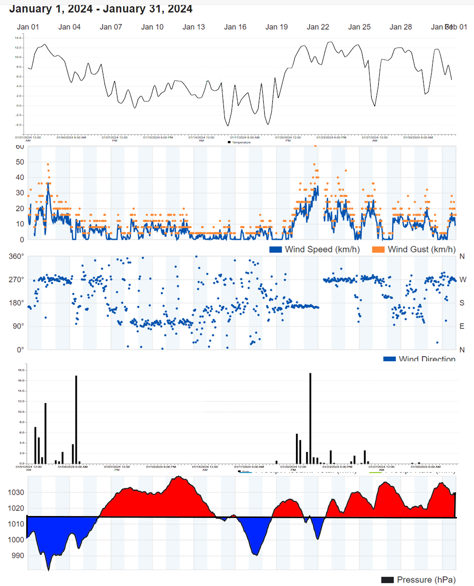
A chart sequence for January 2024 can be viewed here
In summary, January 2024 was slightly colder, had near average rainfall but many more dry days, and was slightly sunnier than average.
When shown * estimates were made using reports from nearby sites in order to calculate missing data. Grass frost estimates use air temp below 4C
Exminster.
Average temp 5.7C. Air frost 10days. Ground frost possible 19 days. Highest 15.1C on 24th. Lowest -6.7C morning of 19th.
Total rain 73.4mm. 18 dry days, 10 days, with 1mm or more, 2 days 10mm or more, 0 days 20mm or more. Wettest day 16.8 on 4th.
Dawlish inland.
Average temp 6C. Air frost 9days. Ground frost possible 20 days. Highest 13.5C on 23rd. Lowest -5.1C morning of 16th and 19th.
Total rain 90mm. 18 dry days, 10 days with 1mm or more, 4 days 10mm or more, 2 days 20mm or more. Wettest day 22mm 21st .
Digital sun 38.6 hours (correction factor 1.8) = 69.5 hours.
Teignmouth Den.
Mean temperature 5.9C (LTA 6.7C). Average Max 9.2C (LTA 9.4C). Highest 13.8C on 2ndh. Average Min 2.5C (LTA 4C). Lowest -3.8C on 16th. Air frost 8 days. (Average 4). Potential 19* ground frosts
Total rain 97.5mm (LTA 95.2mm). 22 dry days (LTA 12), 9 days with 1mm or more (LTA 13). Wettest day 25.6mm on the 1st 0900 to 0900 hours next day. 3 day with >= 10mm. 2 days with >= 20mm.
Total sun *76* hours (LTA 64.7 hours).
Teignmouth Inland.
Average temp 13.2C. Air frost 5days. Ground frost possible 17days. Highest 13.2C on 2nd. Lowest -3.5C morning of 16th.
Total rain 88mm. 16+ dry days, 9 days with 1mm or more, 3 days 10mm or more, 1days 20mm or more. Wettest day 21.1mm 21st .
Digital sun 76.3 hours (correction factor 1) = 76.3 hours.
Bitten Park.
Average temp 6.6C. Air frost 5days. Ground frost possible 15 days. Highest 13.5C on 2nd. Lowest -3.2C morning of 16th.
Total rain 80mm. 20dry days, 9 days with 1 mm or more, 4 days 10mm or more, 1 days 20mm or more. Wettest day 22.4 on 4th.
Netherton.
Average temp 5.5C. Air frost 14days. Ground frost possible 21 days. Highest 13.3C on 26th. Lowest -8.2C morning of 19th.
Total rain 120mm. 18 dry days, 9 days with 1mm or more, 5 days 10mm or more, 2 days 20mm or more. Wettest day 21mm 4th .
Digital sun 39.6 hours (correction factor 1.8) = 71 hours.