The monthly weather summary is prepared as soon as possible each month and is based on unofficial recordings and the opinion of the author. No claim is made about the accuracy of the summary. If you are aware of an error or omission please e-mail mike.trigger@gmail.com (Seasonal summaries available by 10th).
The longer term averages are sourced from the Met Office.
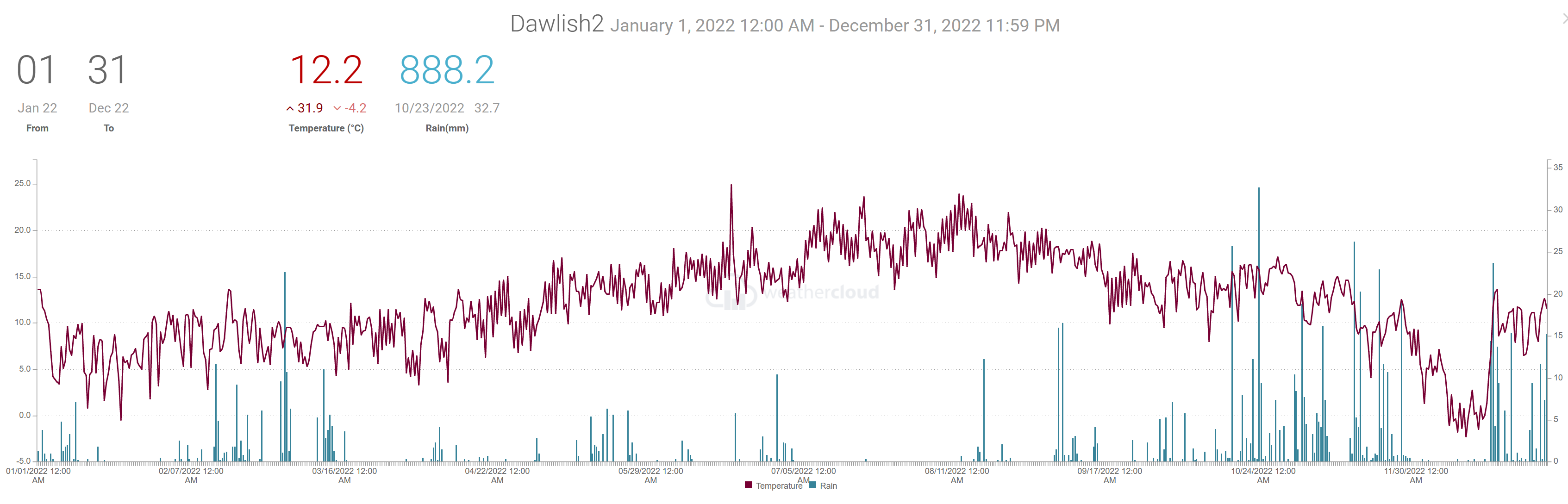
Weather Summary YEAR 2022 010123
Compared to the 30 year average (1981 to 2010), 2022 was warmer, slightly sunnier and had average to slightly above average rainfall despite several drier than average months. For SW England December was the only month with a below average temperature. There were five drier than average months, four with near average rainfall and three wetter than average months.
When shown * estimates were made using reports from nearby sites in order to calculate missing data. Grass frost estimates use air temp below 4C
Teignmouth Den*. DATA will be added when available
Mean temperature 12.2C (LTA 11.C) Frost 12 days Ground frost possible 20 days.
Total rain 932mm (LTA 848). 207 dry days (LTA 190), 113 days with 1mm or more (LTA 122). 24 days 10mm or more(LTA30). 10 days 20mm or more
Total sun 1847 hours (LTA 1747 hours).
Dawlish inland.
Average temp 12.3C. 27 Days with air frost 69 days with possible ground frost
Total rain 894mm. 180 dry days, 120 days with 1mm or more, 27 days 10mm or more, 10 days with 20mm or more.
Digital sun *1837 hours .
108 days with 20C or more. 31 days with 25C or more and 3 days with 30C ore more.
Netherton.
Average temp 11.5C. 49 Days with air frost 99 days with possible ground frost
Total rain 962mm. 187 dry days, 117 days with 1mm or more, 28 days 10mm or more, 9 days with 220mm or more.
Digital sun 1748hours (corrected).
98 days with 20C or more. 25 days with 25C or more and 4 days with 30C ore more.
Weather Summary December 2022 010123
December 2022 was colder and wetter than average overall. There were two distinct weather periods, first a cold and mostly dry 17days followed by 14 days of mild and wet weather.
The month started with High pressure to the North and East with a ridge over the UK. This brought across the district increasingly cold winds from an easterly point and the start of frequent night frosts. By the 8th the High declined as low pressure moved South from the Norwegian Sea and into the North Sea bringing even colder air originating from the Arctic. Although the weather continued mainly dry for the Dawlish and Teignmouth areas there was a little snow in other parts of SW England. Weather fronts associated with Low pressure to the SW of the UK brought some patchy rain and a little snow to the hills in SW England on the 13th and 14th before moving away. A deep low pressure to the west of Ireland started the change from cold and mainly dry to mild but mainly wet weather. Temperatures on the 18th jumped from around 7 Celsius to almost 14 Celsius as mild but very strong SW winds swept across SW England. The remainder of the month was changeable with periods of rain or showers with relatively mild temperatures.
In terms of statistics:
The average temperature for the month was around 6 Celsius, that’s a degree or so below the thirty year average for December and it was the only month in 2022 with a below average temperature. The highest temperature of the month was around 14 Celsius, occurring between the 19th and 21st. There were frequent frosts between the 8th and 17th with the coldest mornings mostly between the 15th and 17th when values between minus 2 and minus 5 Celsius were recorded. Some valleys in the Netherton and Exminster areas recorded values as low as minus 7 Celsius. Typically, there are around 4 nights with an air frost but this December there were between 8 and 12 night frosts although near Exminster and Netherton there were as many as 17 nights with a frost.
Rainfall totals were typically between 120 and 150mm, that’s about 30% more than average. The wettest days were the 18th and 19th with combined totals of 40 to 60mm. The 23rd and 31st were also very wet days. On average there are around 14 dry days in December but this month there was as many as 17 or 18 mostly dry days, despite above average rainfall totals. There were around 12 days with recorded rain of 1mm or more, 5 or 6 days with 10mm or more and a few days with 20mm or more.
Strong winds occurred on the 18th and 19th and between the 27th and 31st.
Sunshine was estimated to be near or a little below the average of 60 hours.
The sea temperature at the Dawlish wave buoy site was around 11 Celsius at the end of the month.
In summary, December 2022 was colder and wetter than average overall. There were two distinct weather periods, first a cold and mostly dry 17days followed by 14 days of mild and wet weather.
When shown * estimates were made using reports from nearby sites in order to calculate missing data. Grass frost estimates use air temp below 4C
Teignmouth Den.
Mean temperature 5.7C (LTA 7.1*C). Average Max 9.2*C (LTA 9.8C). Highest 14.5C on 19th. Average Min 2.3*C (LTA 4.4C). Lowest -2.8C on 15th. Air frost 10. (Average 4 days). Potential 20 days ground frosts
Total rain 160.8*mm (LTA 103mm). 17 dry days (LTA 14), 13 days with 1mm or more (LTA 13). Wettest day 48.1mm on the 18th, 0900 to 0900 hours next day. 4 days with >= 10mm. 3 days with >= 20mm.
Total sun 53.1 hours (LTA 60 hours).
Dawlish inland.
Average temp 5.8C. Air frost 12days. Ground frost possible 16 days. Highest 14.9C on 19th. Lowest -4.4C morning of 14th. Total rain 145mm. 18 dry days, 12 days with 1mm or more, 5 days 10mm or more. 3 days 20mm or more. Wettest day 38mm 18th .
Digital sun **not avilable hours (correction factor 0.9) = *48hours.
Teignmouth Inland.
Average temp 6.1C. Air frost 10days. Ground frost possible 15 days. Highest 13.9C on 19th. Lowest -2.8C morning of 12th. Total rain 146mm. 17 dry days 12 days, with 1mm or more, 6 days 10mm or more, 3 days 20mm or more. Wettest day 43mm 18th .
Digital sun 66 hours (correction factor 0.9) = 59 hours.
Netherton.
Average temp 5C. Air frost 17days. Ground frost possible 19 days. Highest 13.9C on 19th. Lowest -7.4C morning of 12th. Total rain 200mm. 17 dry days, 13 days with 1mm or more, 7 days 10mm or more, 4 days 20mm or more. Wettest day 41mm 18th .
Digital sun not available hours (correction factor 0.9) = ** hours.
Weather Summary Autumn (SON) 2022 021222
Temperature was above average by two to three degrees with recorded means between 12 and 14 Celsius. Rainfall was also two to three times the average with totals 350 to 450mm. Sunshine was also below average.
When shown * estimates were made using reports from nearby sites in order to calculate missing data. Grass frost estimates use air temp below 4C
Teignmouth Den.
Mean temperature 13.8C (LTA 12.3C).
Total rain 475mm (LTA 244mm). 32 dry days (LTA 44), 48 days with 1mm or more (LTA 33). 15 days 10mm or more. 6 days 20mm or more
Total sun *351 hours (LTA 356 hours).
Dawlish inland.
Average temp 13.5C. Total rain 450mm. 26 dry days, 54 days with 1mm or more, 18 days 10mm or more.
Digital sun 321 hours (corrected).
Teignmouth inland.
Average temp 13.2C. Total rain 395mm. 25 dry days, 54 days with 1mm or more, 14 days 10mm or more.
Digital sun 355 hours (corrected).
Netherton.
Average temp 12.5C. Total rain 421mm. 25 dry days, 50 days with 1mm or more, 15 days 10mm or more.
Digital sun 287 hours (corrected).
Weather Summary November 2022 011222
Weather patterns in November were dominated by Atlantic low pressure systems moving over the UK bringing moisture laden Southwesterly winds. The result was milder than average temperatures and quite a lot of rain. The four especially wet periods, centred on the 2nd, 7th, 16th and 21st, were associated with low pressure centres which moved east over or very close to SW England. Following the low on the 16th a brief lull in the winds and clearing skies led to the sudden dip in temperature on the 19th. There was one short mostly dry spell from the 10 to 13th when the influence of high pressure over France and Germany extended across southern England. The rise in pressure on the last day of the month signalled the end of the progression of Atlantic weather systems in favour of colder but drier East winds.
A chart sequence for November 2022 can be viewed here
In terms of statistics:
The average temperature for the month was between 10 and 11 Celsius, that’s a degree or two above the 30 year average for November. The highest temperature of the month, between 17 and 18 Celsius, occurred on the 12th or 13th and the coldest mornings were on the 18th and 19th when temperatures fell low enough for a frost in the more prone locations. The lowest values being on the 19th ranging from minus two Celsius in Netherton to around 3 Celsius near the coast.
Rainfall totals were typically between 180 and 230mm which was over two times higher than a typical November total of around 90mm. The wettest days varied between the 15 and 16th with 20 to 30mm of rain falling each day resulting in two day totals of between about 40 and 55mm. On average there are around 13 dry days in November but this month there was only 6 or 7 days when no rain was recorded in the Dawlish to Exminster area and 4 or 5 days in the Teignmouth to Netherton area. There were around 20 days with recorded rain of 1mm or more, 8 to11 days with 10mm or more and as many as three days with 20mm or more.
(Updated 021222)Sunshine was estimated at around 60 hours in Dawlish but 87 hours in Teignmouth, the average being around 84 hours.
The sea temperature at the Dawlish wave buoy fell during November from 15 Celsius at the start of the month to almost 12 Celsius at the end. Wave heights reached the storm threshold of 2.8 metres on six days during the month associated with windy conditions on the 3rd, 8th,15th, 22nd 24th and 26th.
In summary, November 2022 was very wet but also milder than average.
When shown * estimates were made using reports from nearby sites in order to calculate missing data. Grass frost estimates use air temp below 4C
Teignmouth Den.
Mean temperature 11.2C (LTA 9.3C). Average Max 13.7C (LTA 12.1C). Highest 17C on 13th. Average Min 8.7C (LTA 6.4C). Lowest 1.7C on 20th. Air frost 0. (Average 1). Potential 2 ground frosts
Total rain 229mm (LTA 89mm). 8 dry days (LTA 13), 21 days with 1mm or more (LTA 12). Wettest day 25mm on the 14th and 16th 0900 to 0900 hours next day. 7 days with >= 10mm (LTA 3-4). 4 days with >= 20mm.
Total sun *8.9* hours (LTA 84 hours).
Dawlish inland.
Average temp 10.7C. Air frost 1 days. Ground frost possible 3 days. Highest 17C on 12th. Lowest 0 C morning of 19th. Total rain 230mm. 7 dry days, 21days with 1mm or more, 11 days 10mm or more. 4 days 20mm or more. Wettest day 31mm 15th .
Digital sun 57 hours (correction factor 0.0) = 57 hours.
Teignmouth Inland.
Average temp 10.7C. Air frost 0 days. Ground frost possible 1 days. Highest16.8C on 13th. Lowest 1.7C morning of 19th. Total rain 202mm. 5 dry days, 20 days, with 1mm or more, 8 days 10mm or more, 3 days 20mm or more. Wettest day 30.2mm 15th .
Digital sun 101 hours (correction factor 0.8) = 80 hours.
Netherton.
Average temp 10C. Air frost 2 days. Ground frost possible 6 days. Highest 17.3C on 12th. Lowest -2C morning of 19th. Total rain 223mm. 4 dry days, 20 days with 1mm or more, 10 days 10mm or more, 3 days 20mm or more. Wettest day 30mm 15th .
Digital sun 38.7 hours (correction factor 0.0) = 39 hours.
Weather Summary October 2022 01NOV2022
Weather patterns in October were changeable leading to an unsettled month overall. The first half of the month saw short lived ridges of higher pressure develop in between Atlantic weather systems driven by winds from a mostly south-westerly point. During the second half of the month a series of pressure centres developed to the Southwest of the UK. These produced southerly winds which were unusually warm although there were also frequent spells of rain which were at times heavy and thundery.
A chart sequence for October 2022 can be viewed here
In terms of statistics:
The average temperature for the month was between 14.5 Celsius, that’s about 2 degrees above the 30 year average. The highest temperature occurred at the start of the month with top values around 21 Celsius in the Teignmouth area on the 1st and Dawlish area on the 2nd. Due to “warm” southerly winds the day and night temperatures from the 19th were unusually high. The coldest night of the month was on the 11th when temperatures fell to around 5 or 6 Celsius in most places but to 2 or 3 Celsius in some of the valleys and to just above freezing in Netherton. In fact the temperature at Exeter airport did fall below freezing on the 11th so it is possible that some sheltered parts of this district had a ground frost.
Rainfall totals were typically between 120 and 150mm which was above the October average of 90 to 100mm. The wettest day was the 23rd when 30mm to 40mm occurred during a particularly thundery spell. Typically, October has roughly equal numbers of dry and “rain” days (defined as days with 1mm or more of rainfall). This month, however, there were 17 to 21 rain days across the district and between 5 and 8 dry ones. There were 3 or 4 days with at least 10mm of rain recorded in 1 or 2 days with 20mm or more.
Sunshine was estimated at around 110 hours which is close to the average.
The sea temperature at the Dawlish wave buoy has been steady at 16 Celsius for most of October.
In summary, October 2022 was much milder and much wetter than average.
When shown * estimates were made using reports from nearby sites in order to calculate missing data. Grass frost estimates use air temp below 4C
Teignmouth Den. added 10th rainfall suspect total.
Mean temperature *14.4C (LTA 12.3). Average Max *17.2C (LTA 15.2). Highest 19.9C on 1st. Average Min *11.6C (LTA 9.3C). Lowest 5.5C on 11th. Air frost 0. (Average 0). Potential 0 ground frosts
Total rain *177.9*mm (LTA 97.3mm). 8 dry days (LTA 14), 17 days with 1mm or more (LTA 12). Wettest day 41mm on the 22nd 0900 to 0900 hours next day (mostly on 23rd). 6 days with >= 10mm. 2 days with >= 20mm.
Total sun *112* hours (LTA 110.6 hours).
Dawlish inland.
Average temp 14.5C. Air frost 0 days. Ground frost possible 1 day. Highest 21C on 2nd. Lowest 2.5C morning of 11th. Total rain 150mm. 5 dry days, 22 days with 1mm or more, 4 days 10mm or more. 2 days 20mm or more. Wettest day 40mm 23rd.
Digital sun 132 hours (correction factor 0.9) = 119 hours.
Dawlish Coast.
Average temp 14.8C. Air frost 0days. Ground frost possible 0 days. Highest 21C on 2nd. Lowest 5.5C morning of 11th. Total rain 117mm. 7 dry days, 18 days with 1mm or more, 3 days 10mm or more, 1 days 20mm or more. Wettest day 37mm 23rd.
Teignmouth Inland.
Average temp 14.4C. Air frost 0 days. Ground frost possible 0 days. Highest 21.3C on 1st. Lowest 5.1C morning of *11th. Total rain 136mm. 4 dry days 22 days, with 1mm or more, 4 days 10mm or more, 2 days 20mm or more. Wettest day 39mm 23rd .
Netherton.
Average temp 13.4C. Air frost 0 days. Ground frost possible 3 days. Highest 20C on 1/2nd. Lowest 0.8C morning of 11th. Total rain 130mm. 6 dry days, 18 days with 1mm or more, 3 days 10mm or more, 1 day 20mm or more. Wettest day 32.5mm 23rdh .
Digital sun 115.2 hours (correction factor 0.9) = 103.5 hours.
Weather Summary September 2022 011022
A low pressure centre moving south from Iceland and another over NW France combined to produce a persistent area of low pressure to the SW of Ireland. This brought a series of weather fronts across SW England resulting in a wet and breezy spell of weather from the 3rd to the 9th. The 4th and 5th were especially wet with over an inch of rain across the district including thunderstorms and associated heavy rain on the 5th. The low eventually weakened and moved east over England to be followed by the briefest of ridges. A further area of low pressure brought a weather front across the district on the 13th and this lingered into the 14th. High pressure then developed to the west, edging across SW England on the 18th and lasting until the 25th apart from a weakening cold front which crossed the area on the 22nd. From the 26th cold fronts accompanied by strong W to NW winds spread south over the country bringing an unsettled end to the month.
In terms of statistics:
The average temperature for the month was between 15 and 16 Celsius, slightly above the 30 year average. The highest temperatures occurred in the early or middle part of the month although there was a more prolonged warm spell centred on the 22nd. Top temperatures were between 22 and 25 Celsius in most parts. The lowest temperature for many was on the morning of the 17th with typical lows of around 5 to 7 Celsius although the last night or two of the month saw the temperature dipping to 2 Celsius in the Netherton area which was just about low enough for a touch of ground frost.
Rainfall totals were typically between 60 and 70mm which was slightly above average for September. The wettest day was either the 4 or 5th with accumulations over the two days around 30mm. There were between 13 and 17 dry days across the district and between 9 and 12 days with 1mm or more of rain.
Sunshine estimated at around 145 hours was below the average of 160 hours.
The sea temperature at the Dawlish wave buoy decreased from 19 Celsius at the start of the month to 16 Celsius by the 30th.
A chart sequence for September 2022 can be viewed here
In summary, September 2022 was a little warmer, wetter and cloudier than average
When shown * estimates were made using reports from nearby sites in order to calculate missing data. Grass frost estimates use air temp below 4C
Teignmouth Den. updated 051022
Mean temperature *15.7C (LTA 15.2C). Average Max *19.1C (LTA 18.6C). Highest 22*C on 2nd. Average Min *12.3C (LTA 11.7C). Lowest *5.9C on 17th. Air frost 0. (Average 0. Potential 0 ground frosts
Total rain 67.9*mm (LTA 57.5mm). 16* dry days (LTA 17), 10* days with 1mm or more (LTA 9). Wettest day 15mm on the 4/5th. 2* dasy with >= 10mm. *0 days with >= 20mm.
Total sun 151.9* hours (LTA 160.6 hours).
Dawlish inland.
Average temp 15.3C. Air frost 0 days. Ground frost possible 0 days. Highest 24C on 14th. Lowest 4.5C morning of 17 and 30th. Total rain 70mm. 14 dry days, 11 days with 1mm or more, 2 days 10mm or more. 0 days 20mm or more. Wettest day 17mm 4th .
Digital sun 182 hours (correction factor 0.8) = 145 hours.
Dawlish Coast.
Average temp 15.9C. Air frost 0days. Ground frost possible 0 days. Highest 23.2C on 10th. Lowest 7.1C morning of 17th. Total rain 67.6mm. 17 dry days, 10 days with 1mm or more, 2 days 10mm or more, 0 days 20mm or more. Wettest day 16.3mm 4th .
Teignmouth Inland.
Average temp 15.7C. Air frost 0 days. Ground frost possible 0 days. Highest 22.7C on 1st. Lowest 6.6C morning of 17th. Total rain 67mm. 16 dry days, 12 days, with 1mm or more, 2 days 10mm or more, 0 days 20mm or more. Wettest day 15mm 4 and 5th .
Digital sun 208.5 hours (correction factor 0.7) = 146 hours.
Netherton.
Average temp 14.2C. Air frost 0days. Ground frost possible 1 day. Highest 23.1C on 2nd. Lowest 2C morning of 30th. Total rain 68.1mm. 15 dry days, 12 days with 1mm or more, 2 days 10mm or more, 0 days 20mm or more. Wettest day 19.6mm on 4th .
Digital sun 180 hours (correction factor 0.8) = 144 hours.
Weather Summary Summer (JJA) 2022 020922
A fine and warm summer - heat waves and drought. Temperature at least a degree above average. Rainfall about one third of average. Sunshine above average.
When shown * estimates were made using reports from nearby sites in order to calculate missing data. Grass frost estimates use air temp below 4C
Teignmouth Den.
Mean temperature 17.4*C (LTA 16.5C). Average Max 21.6*C (LTA 20.1C). Average Min 13.2*C (LTA 13C).
Total rain 46.4*mm (LTA 150mm). 75* dry days (LTA 57), 11 days with 1mm or more (LTA 23). 1 days 10mm or more.
Total sun 716* hours (LTA 657** hours).
Dawlish inland.
Average temp 17.7C. Total rain 53.5mm.68 dry days, 12 days with 1mm or more, 2 days 10mm or more.
Digital sun 672 hours (corrected)..
Netherton.
Average temp 17C. Total rain 50.9mm. 68 dry days, 12 days with 1mm or more, 0 days 10mm or more.
Digital sun 687 hours (corrected).
Weather Summary August 2022 010922
Low pressure moved across northern Scotland early in the month but the associated weather fronts which crossed the area on the 3rd and 4th failed to produce much rain. High pressure then built in from the west across southern England bringing largely warm and sunny weather, leading to an especially warm spell between the 10th and 14th. Between the 15th and 18th low pressure moved close to SW England bringing thundery rain across the district. The showery nature of the rain meant that totals were varied across the district but most places saw their wettest day of the month on the 17th. The weather remained slightly unsettled through to the 25th but weak weather systems gave little in the way of rain and settled weather returned as higher pressure developed during the last week of the month.
Rainfall has been well below average since April and followed a drier than average Winter resulting in a declaration of drought across SW England.
In terms of statistics:
The average temperature for the month was around 19 Celsius which was a degree or two above the thirty year average. The warmest day was on the 11th when most places got close to or exceeded 30 Celsius. Coastal areas where a little cooler though still above 25 Celsius. There were only a few days when temperatures did not reach 20 Celsius and afternoon temperatures reached at least 25 Celsius on 6 days at the coast and as many as 20 days inland. The temperature reached 30 Celsius in inland parts for several days between the 10th and 14th. The coldest morning, with a temperature between 7 and 11 Celsius, was on the 6th for most parts but a few places had similar values on the 26th.
Average rainfall is around 55mm in August but across the district totals ranged from only 10mm near the river Teign to 15mm to 20mm near Dawlish and around 25mm closer to the river Exe. There were between 22 and 28 days with no recorded rain.
Sunshine at around 260 hours was about 20% above average for August.
The sea temperature at the Dawlish wave buoy varied between 19 and 21 Celsius during the month.
In summary, August was much warmer and sunnier than average and very dry.
When shown * estimates were made using reports from nearby sites in order to calculate missing data. Grass frost estimates use air temp below 4C
Teignmouth Den.
Mean temperature 18.7*C (LTA 17.2C). Average Max 22.7*C (LTA 20.7C). Highest 26C on 11/12/13th. Average Min *14.79C (LTA 13.7C). Lowest 11.5C on 6,7,26,29th. 6 days with 25C or more.
Total rain 9.9*mm (LTA 54.1mm). 28 dry days (LTA 18), 3 days with 1mm or more (LTA 8). Wettest day 4.8mm on the 17th 0900 to 0900 hours next day. 0 day with >= 10mm. 0 days with >= 20mm.
Total sun 258.5* hours (LTA 209.6hours).
Dawlish inland.
Average temp 19C. Highest 31C on 11th. Lowest 9.4C morning of 6/26th. 14 days with 25C or more. Total rain 20mm. 23 dry days, 3 days with 1mm or more, 1 days 10mm or more. 0 days 20mm or more. Wettest day 12mm 17th .
Digital sun 265.8 hours (correction factor 0.9) = 240 hours.
Teignmouth Inland.
Average temp 19.5C. Highest 27.5C on 13th. Lowest 11.5C morning of 26th. 7 days woyth 25C or more. Total rain 14.5mm. 24 dry days 3 days with 1mm or more, 0 days 10mm or more, 0 days 20mm or more. Wettest day 5.6mm 17th .
Digital sun 305.6 hours (correction factor 0.9) = 275 hours.
Netherton.
Average temp 18.4C. Highest 31.5C on 12th. Lowest 6.8C morning of 6th. 11 days with 25C or more. Total rain 9.6mm. 25 dry days, 3 days with 1mm or more, 0 days 10mm or more, 0 days 20mm or more. Wettest day 4.1mm 22nd.
Digital sun 268.7 hours (correction factor 0.8) = 241.8 hours.
Weather Summary July 2022 01AUG2022
Low pressure crossing Scotland brought a series of weak weather fronts across the district at the start of the month producing a little rain. High pressure moved eastwards across the country with the centre of the high over England on the 10th. The High continued East to be replaced by another extension of the Azores High across England and Wales by the middle of the month. Low pressure moving North from Biscay brought some hit and miss showery rain across the district between the 17th and 20th with thunder heard in Dawlish on the 19th. Despite this there was little in the way of rainfall totals to show for this less settled spell. Low pressure moving East over Scotland brought some weak weather fronts across the district between the 23rd and 25th and again on the 30th and 31st. These produced spells of light rain or drizzle which evaporated quickly in the warm and breezy conditions.
In terms of statistics:
The average temperature for the month was 18 to 19 Celsius, over a degree above the thirty year average. The warmest day was on the 19th when most got close to 30 Celsius and even coastal areas where in the high twenties. For most there were at least 28 days when temperatures exceeded 20 Celsius. Afternoon temperatures reached at least 25 Celsius on 3 to 6 days at the coast and as many as 14 days inland. A few inland parts had 2 or 3 days when the temperature reached 30 Celsius. The coldest morning, with a temperature between 7 and 10 Celsius, was on the 1st for most parts but a few places had similar values on the 27th although the Netherton area dipped to 5 Celsius on the 5th.
Rainfall totals across the district were between 1 and 5mm, which is well below the average of 45mm. There were around 28 days with no recorded rain which compares with the July average of about 20 days. Rainfall totals in February and March were near average but other months this year have recorded below average values.
The strongest winds were on the 24th associated with low pressure moving across Scotland producing a strong South-Westerly across the district.
Sunshine at around 240 hours was above average for July.
The sea temperature at the Dawlish wave buoy increased form 15 Celsius at the start of July to around 18 Celsius by the middle of the month.
In summary, July 2022 was warmer and sunnier than average and exceptionally dry.
When shown * estimates were made using reports from nearby sites in order to calculate missing data. Grass frost estimates use air temp below 4C
Teignmouth Den.
Mean temperature 18.2C (LTA 17.3C). Average Max 22.4C (LTA 20.8C). Highest 28.4C on 19th. Average Min 13.9*C (LTA 13.7C). Lowest 10C on 5th.
27 days with max 20C or more, 3 days with max 25C or more.
Total rain 2.4mm (LTA 45.5mm). 28 dry days (LTA 20), 1 days with 1mm or more (LTA 7). Wettest day 1.8mm on the 1st 0900 to 0900 hours next day. 0 day with >= 10mm. 0 days with >= 20mm.
Total sun *232.6 hours (LTA 225 hours).
Dawlish inland.
Average temp 18.5C. Highest 30C on 19th. Lowest 8C morning of 1st.
29 days with max 20C or more, 14 days with max 25C or more.
Total rain 2.2mm. 28 dry days, 1 days with 1mm or more, 0 days 10mm or more. 0 days 20mm or more. Wettest day 1.8mm 2nd.
Digital sun 303 hours (correction factor 0.8) = 242 hours.
Teignmouth Inland.
Average temp 18.7C. Highest 29.3C on 19th. Lowest 10.1C morning of 1st.
29 days with max 20C or more, 8 days with max 25C or more.
Total rain 3mm. 26 dry days 1 day, with 1mm or more, 0 days 10mm or more, 0 days 20mm or more. Wettest day 2.3mm 2nd.
Digital sun 350 hours (correction factor 0.8) = 280 hours.
Netherton.
Average temp 17.7C. Highest 28.6C on 19th. Lowest 5.5C morning of 5th.
29 days with max 20C or more, 10 days with max 25C or more.
Total rain 4.2mm. 27 dry days, 1 days with 1mm or more, 0 days 10mm or more, 0 days 20mm or more. Wettest day 3.3mm 2nd .
Digital sun 301 hours (correction factor 0.8) = 240 hours.
Weather Summary June 2022 100722
June was drier and slightly warmer than average with near average sunshine.
June started with mostly high pressure and east or northeast winds before weak fronts and lower pressure brought patchy rain between the 4th and 8th. This was followed by the longest dry period of the month when higher pressure dominated and most days seeing afternoon temperature over 20 Celsius. Just before a cold front brought some rain on the 18th exceptionally warm air from Spain and France moved into southern parts of England. This produced one flaming June day when temperatures widely reached 30 Celsius reaching as high as 33 Celsius inland. There was another short dry period between the 20 and 23rd before SW winds and lower pressure again brought a little rain.
In terms of statistics:
The average temperature for June was around 15.5 Celsius, only fractionally above the 1981-2010 value. Temperatures rose above 20 Celsius on at least 18 days inland and 13 days near the coast and reached 25 Celsius inland on at least 3 days. The hottest day was the 17th when with only very light winds, inland temperatures reached over 30 Celsius. The coldest morning was on the 1st when the low was around 6 Celsius for most but as low as 2 Celsius in Netherton.
June rainfall totals across the district ranged from 25mm to 40mm which is roughly two thirds of the thirty-year average. There was a typical number of dry days (19) and days with 1mm or more of rain (7). The wettest day was on the 28th when around 10mm was recorded. Rainfall across SW England was more varied due to the showery nature of summer rain with some places, even as close as Exeter, seeing above average rain.
The strongest winds were on the 9th when a fairly deep low pressure moved over the West of Scotland and brough strong SW winds across the district.
Sunshine at around 220 hours was close to the average for June but sunnier than last year.
In summary, June was drier than average and slightly warmer than average with near average sunshine
When shown * estimates were made using reports from nearby sites in order to calculate missing data. Grass frost estimates use air temp below 4C
Teignmouth Den.
Mean temperature 15.3C (LTA 15.2C). Average Max 19.6C (LTA 18.7C). Highest 25C on 17th. Average Min 11C (LTA 11.6C). Lowest 7.1C on 1st.
Total rain 34.1mm (LTA 50.5mm). 19 dry days (LTA 19), 7 days with 1mm or more (LTA 8). Wettest day 14mm on the 28th 0900 to 0900 hours next day. 1 day with >= 10mm (LTA 2). 0 days with >= 20mm.
Total sun 225.3* hours (LTA 222.4 hours).Days with afternoon temperature 20C or more = 19 days. 25C or more 3 days.
Dawlish inland.
Average temp 15.9C. Air frost 0days. Ground frost possible 0 days. Highest 33C on 17th. Lowest 5.7C morning of 1st. Total rain 30.2mm. 17 dry days, 7 days with 1mm or more, 1 day 10mm or more. 0 days 20mm or more. Wettest day 10.4mm 28th.
Digital sun 272 hours (correction factor 0.8) = 217 hours.
Days with afternoon temperature 20C or more = 19 days. 25C or more 1 day.
Teignmouth Inland.
Average temp 15C. Air frost 0 days. Ground frost possible 0 days. Highest 31.5C on 17th. Lowest 8C morning of 1st. Total rain 33mm. 17 dry days. 7 days with 1mm or more, 1 days 10mm or more, 0 days 20mm or more. Wettest day 11mm 28th .
Digital sun 322 hours (correction factor 0.8) = 257 hours.
Days with afternoon temperature 20C or more = 18 days. 25C or more 1 day.
Netherton.
Average temp 15C. Air frost 0days. Ground frost possible 1 days. Highest 30.1C on 17th. Lowest 2.3C morning of 15th. Total rain 37.1mm. 16 dry days, 8 days with 1mm or more, 0 days 10mm or more, 0 days 20mm or more. Wettest day 9.1mm 28th .
Digital sun 290.8 hours (correction factor 0.8) = 232 hours.
Days with afternoon temperature 20C or more = 18 days. 25C or more 4 days.
Weather Summary Spring (MAM) 2022 030622
Above average temperature, above average sunshine and below average rainfall.
When shown * estimates were made using reports from nearby sites in order to calculate missing data. Grass frost estimates use air temp below 4C
Teignmouth Den.
Mean temperature 10.6C (LTA 9.9C). Average Max 14.3C (LTA 13.1C). Average Min 6.9C (LTA 6.7C). Air frost 0. (Average 0).
Total rain 145mm (LTA 187mm). 55 dry days (LTA 49), 21 days with 1mm or more (LTA 30). 2 days with >= 10mm (LTA 6), 1 days with 20mm or more.
Total sun 580 hours (LTA 526 hours).
Dawlish inland.
Average temp 10.9C. Air frost 3 days. Total rain 140mm. 59 dry days, 26 days with 1mm or more, 3 days 10mm or more. 1 day with 20mm or more.
Digital (corrected) = 557hours.
Teignmouth Inland.
Average temp 11C. Air frost 0 day. Total rain 141mm.54 dry days, 25 days with 1mm or more. 3 days 10mm or more. 1 day with 20mm or more
Netherton.
Average temp 10C. Air frost 10 days. Total rain 146.6mm. 60 dry days, 21 days with 1mm or more, 3 days 10mm or more, 1 day with 20mm or more.
Digital sun (corrected) = 571 hours.
Weather Summary May 2022 020622
May was milder and cloudier than average and the total rain for the month was below average.
A weak weather system moved south across the district at the start of the month through a fairly weak high pressure area. High pressure developed over and to the south of England resulting in over a week of dry weather. The high declined as Atlantic westerlies brought stronger winds and some rain for the 11th. Then the high pressure edged back north over southern England for another couple of days. After this showery, even thundery, rain moved north from France to start a slightly unsettled spell around the middle of the month. Low pressure moved in from the west by the 23rd bringing some further, mostly light rain. High pressure again developed over and to the west of Britain before declining as low pressure spread south over England bringing showers. This brought some locally heavy thundery rain to areas just to the North and West of the district but they mostly skirted around the Dawlish and Teignmouth area.
In terms of statistics:
Rainfall totals across the district were typically between 40 and 45 mm which is below average for May and follows on from a dry April. The wettest day for most was either on the 18th or the 23rd with below 10mm recorded. There were around 18 dry days, which is about normal for May, although there were around 12 days when 1mm or more of rain was recorded which was somewhat more than the average of 9 days.
The temperature for the month averaged around 13.4 Celsius, a degree above the 30 year average. The warmest day occurred on the 5th or 7th when temperatures reached 20 to 23 Celsius in most places. There were several days when the afternoon temperature reached at least 20 Celsius and in parts of Dawlish this occurred on as many as 8 Days. The coldest temperature for most of the district occurred on the 5th or the 9th when values dipped to between 5 and 7 Celsius. A few inland areas saw temperatures falling close to 3 Celsius which is low enough for a possible ground frost although most parts remained frost free.
Breezy spells occurred between the 10th and 11th and again on the 17th 20th and 26th but for most of May winds were fairly light.
The sea temperature at the Dawlish wave buoy started the month at 12 Celsius, rose to 14 Celsius by the end of the month.
Sunshine, estimated at around 200 hours, was a little below average.
In summary, compared to the 1981 to 2010 average, May 2022 was mild, a little cloudier and had a lower rainfall total.
When shown * estimates were made using reports from nearby sites in order to calculate missing data. Grass frost estimates use air temp below 4C
Teignmouth Den.
Mean temperature 13.1C (LTA 12.4C). Average Max 17.1C (LTA 15.7*C). Highest 19.6C on 7th. Average Min 7.3C (LTA 9C). Lowest 4.8C on 4th. Air frost 0. (Average 0). Potential 0 ground frosts
Total rain 43.7*mm (LTA 58.8mm). 17 dry days (LTA 17), 10 days with 1mm or more (LTA 9). Wettest day 7.8*m on the 23rd 0900 to 0900 hours next day. 0 day with >= 10mm. 0 days with >= 20mm.
Total sun 205 hours (LTA 217.5 hours).
Dawlish inland.
Average temp 13.7C Air frost 0 days. Ground frost possible 0 days. Highest 23C on 5th. Lowest 5C morning of 9th. 9 days with temperature 20C or more. Total rain 45mm. 18 dry days, 12 days with 1mm or more, 0 days 10mm or more. 0 days 20mm or more. Wettest day 7mm 23rd.
Digital sun 272 hours (correction factor 0.7) = 200 hours.
Teignmouth Inland.
Average temp 13.8C. Air frost 0 days. Ground frost possible 0 days. Highest 21C on 7th. Lowest 7.8C morning of 4th. Total rain 42mm. 16 dry days. 12 days, with 1mm or more, 0 days 10mm or more, 0 days 20mm or more. Wettest day 6.9mm 23rd.
Digital sun 322 hours (correction factor 0.7) = 225 hours.
Netherton.
Average temp 12.8C. Air frost 0 days. Ground frost possible 1 day. Highest 21.1C on 5th. Lowest 3.2C morning of 9th. Total rain 40.4mm. 17 dry days, 8 days with 1mm or more, 0 days 10mm or more, 0 days 20mm or more. Wettest day 9.9*mm 23rd .
Digital sun 293 hours (correction factor 0.7) = 205 hours.
Weather Summary April 2022 updated 2 May
April recorded well below average rainfall but slightly above average temperatures and sunshine.
The month started with cold northerly winds between high pressure centred just to the west of Ireland and low pressure to the east of the UK. From the 4th, winds from the west brought slightly milder temperatures but also some rain. This was caused by a number of weak weather fronts crossing the area associated with low pressure across northern Scotland. On the 8th a low pressure centre moved over northern France and was close enough to bring rain across the district. This produced what turned out to be the wettest day of the month, though with only 5 or 6mm of rain. A weak ridge formed on the 9th before a series of slow moving Atlantic low pressure systems approached from the west. The lows made little progress as high pressure held firm over Denmark but there was a little rain from weak Atlantic fronts between the 12th and 19th. Between the 20th and 25th milder air brought higher daytime temperatures but easterly winds were often quite strong making it feel colder. High pressure then developed across England bringing dry weather through to the end of the month.
A chart sequence for April 2022 can be viewed here
In terms of statistics:
Rainfall totals across the district were between 13 and 20mm which is less than a third of typical April rainfall. The wettest day for most was on the 8th with only 5 or 6mm and there were around 19 dry days. There were 4 days when at least 1 mm of rain fell which is less than half the average number of days.
The temperature for the month averaged around ten Celsius which was about half a degree above the 30 year average. The warmest day was the 24th when temperatures reached between 17 Celsius at the coast and 19 or 20 Celsius inland. The coldest temperature for most of the district was on the morning of the 3rd when inland areas had a widespread frost and coastal areas only just avoided an air frost. Inland ground frost was probably a little more frequent that normal. Netherton recorded 6 nights with an air frost with the coldest value minus 3.6 Celsius although Exeter airport almost reached minus 5 Celsius.
Windy spells occurred between the 4th and 7th when winds were from the west or northwest and on the 10th and 22nd when winds were from the east.
Sunshine, estimated at around 200 hours, was a little above average.
The sea temperature at the Dawlish wave buoy started the month at 10 Celsius, rose to 12 Celsius by the end of the month.
In summary, compared to the 1981 to 2010 average, April 2022 was much drier, slightly milder and a little sunnier.
When shown * estimates were made using reports from nearby sites in order to calculate missing data. Grass frost estimates use air temp below 4C
Teignmouth Den.
Mean temperature *9.9C (LTA 9.5C). Average Max *13.8C (LTA 12.8C). Highest *17.4C on 23/25th. Average Min *5.9C (LTA 6.1C). Lowest 0.5C on 3rd. Air frost 0. (Average 0). Potential 5 ground frosts
Total rain *20.1mm (LTA 58.4mm). *19 dry days, 3 days with 1mm or more (LTA 10). Wettest day 5.2mm on the 7th 0900 to 0900 hours next day. 0 day with >= 10mm. 0 days with >= 20mm.
Total sun 207* hours (LTA 186.3) hours).
Dawlish inland.
Average temp 10.3C. Air frost 2days. Ground frost possible 10 days. Highest 19.7C on 20/24th. Lowest -1.5C morning of 3rd/10th. Total rain 15.2mm. 20 dry days, 4 days with 1mm or more, 0 days 10mm or more. 0 days 20mm or more. Wettest day 5.6mm 8th .
Digital sun 247 hours (correction factor 0.8) = 197 hours.
Teignmouth Inland.
Average temp 10C. Air frost 0days. Ground frost possible 5 days. Highest 17.8C on 27th. Lowest 0.2C morning of 10th. Total rain 17mm includes. 18 dry days. 6 days, with 1mm or more. 0 days 10mm or more. 0 days 20mm or more. Wettest day 4mm 8th .
Digital sun 287 hours (correction factor 0.8) = 230 hours.
Netherton.
Average temp 9.2C. Air frost 6days. Ground frost possible 18 days. Highest 19.1C on 15th. Lowest -3.6C morning of 1st and 3rd. Total rain 14.5mm. 20 dry days, 4 days with 1mm or more, 0 days 10mm or more, 0 days 20mm or more. Wettest day 4.8mm 8th .
Digital sun 253 hours (correction factor 0.8) = 202 hours.
Weather Summary March 2022 010422
March was milder and sunnier and despite rainfall totals being near or a little above average there were more dry days.
March started very wet as low pressure, which was close to the Isles of Scilly, trailed weather fronts across the district as the low trundled slowly north. From the 4th a ridge of high pressure developed bringing several dry days. The high pressure slipped eastwards allowing low pressure to edge in from the west leading to changeable weather between the 9th and 16th. High pressure then developed leading to a predominantly dry second half of the month, until a weak cold front brought some showers and even a few snow flurries on the 31st.
A chart sequence for March 2022 can be viewed here
In terms of statistics:
Rainfall totals across the district were between 60 and 90mm which is near or a little above average. The higher totals were partly due to the 20 to 40mm of rain that fell on the 1st and 2nd of the month. Despite the higher rain totals there were fewer wet days, 8 days compared to 11 days. There were around 21 dry days compared to the long term average of 15 days.
The temperature for the month averaged out between eight and a half and nine Celsius which was about half a degree above average. The warmest day was the 24th when temperatures reached 17 Celsius at the coast and a degree or two higher inland. The coldest temperatures for many were on the morning of the 31st but some places were colder on the 17th. Coastal areas remained free from air frost but inland there was some. Netherton for example recorded 4 nights with an air frost. In general there were several nights when a ground frost occurred.
Winds were often from between South and East and there were several quite windy days (7, 11, 12 and 19th) and anticyclonic southeasterlies probably produced the strongest winds on the 7th.
The sea temperature at the Dawlish wave buoy started the month at 9 Celsius, rose to 11 Celsius in the sunshine but dropped back to 10 Celsius at the end of the month.
Sunshine, estimated at around 160 hours, was well above average.
In summary, compared to the 1981 to 2010 average, March 2022 was milder, sunnier and wetter in terms of rain totals but had fewer wet days.
When shown * estimates were made using reports from nearby sites in order to calculate missing data. Grass frost estimates use air temp below 4C
Teignmouth Den. to be added if/when available
Mean temperature *8.7C (LTA 7.9C). Average Max *11.9C (LTA 10.9C). Highest 17*C on 24th. Average Min *5.6C (LTA 4.9*C). Lowest 1.5C on 14th. Air frost 0. (Average 1). Potential *7 ground frosts
Total rain *81.5mm (LTA 69.4mm). *19 dry days (LTA 15), 8 days with 1mm or more (LTA 11). Wettest day 26*mm on the 1st 0900 to 0900 hours next day. 2 day with >= 10mm (LTA 2 or 3). 1 days with >= 20mm.
Total sun 164* hours (LTA 122.6 hours).
Dawlish inland.
Average temp 8.8C. Air frost 1 days. Ground frost possible 14 days. Highest 18.9C on 24th. Lowest 0 C morning of 17th. Total rain 81mm. 21 dry days, 8 days with 1mm or more, 3 days 10mm or more. 1 day 20mm or more. Wettest day 23.9mm 1st .
Digital sun 167.7 hours (correction factor 0.96) = 160 hours.
Teignmouth Inland.
Average temp 9.2C. Air frost 0 days. Ground frost possible 5 days. Highest 16.7C on 24th. Lowest 2.3C morning of 17th and 24th. Total rain 82mm. 20 dry days. 8 days with 1mm or more. 3 days 10mm or more, 1 day 20mm or more. Wettest day 23mm 1st .
Digital sun 219 hours (correction factor 0.8) = 175 hours.
Netherton.
Average temp 8C. Air frost 4 days. Ground frost possible 17 days. Highest 17.6C on 24th. Lowest -1.4C morning of 24th. Total rain 92mm. 22 dry days, 8 days with 1mm or more, 3 days 10mm or more, 1 days 20mm or more. Wettest day 27.1mm 1st.
Digital sun 181.2 hours (correction factor 0.9) = 164 hours.
Weather Summary Winter (DJF) 2021-2022 020322
Well above average temperature, below average rain and sunshine. No lying snow.
When shown * estimates were made using reports from nearby sites in order to calculate missing data. Grass frost estimates use air temp below 4C
Teignmouth Den.
Mean temperature 8.2C (LTA 6.7C). Average Max 11.1C (LTA 9.4C). Average Min 5.3C (LTA 4C). Air frost 2. (Average 12).
Total rain 225mm (LTA 270mm). 37 dry days (LTA 38), 37 days with 1mm or more (LTA 36). 4 days with >= 10mm (LTA 6), 1 days with 20mm or more.
Total sun 181 hours (LTA 208.6 hours).
Dawlish inland.
Average temp 8.2C. Air frost 12 days. Total rain 213mm. 39 dry days, 37 days with 1mm or more, 5 days 10mm or more. 1 day with 20mm or more.
Digital (corrected) = 193hours.
Teignmouth Inland.
Average temp 8.5C. Air frost 1 day. Total rain 214mm. 29 dry days, 39 days with 1mm or more.
Netherton.
Average temp 7.6C. Air frost 23 days. Total rain 259mm. 28 dry days, 37 days with 1mm or more, 6 days 10mm or more, 1 day with 20mm or more..
Digital sun (corrected) = 189 hours.
Weather Summary February 2022 010322
February was exceptionally mild, had average sunshine hours and despite average rainfall totals there were fewer dry days.
February 2022 was an unsettled month due to Atlantic low pressure systems sweeping east and bringing weather fronts across the UK. Despite this, pressure was a little above the long term average for SW England. Most of the low pressure centres were well to the north but on the 13th a low pressure centre moved northeast past Cornwall and over Wales which produced the wettest day of the month. The month was often rather windy especially so when a series of three named storms crossed the UK. On the 16th, storm Dudley moved across the south of Scotland and brought wind gusts of around 50 mph across the district. Storm Eunice on the 18th was an explosive deepening wave depression and the subject of Met Office Amber and the rarer Red Warnings for wind across SW England. This was the first use of a Red Warning in the SW of England. During the storm, wind gusts of around 70mph occurred across the district resulting in some temporary power loss and a number of downed trees. This was followed on the 21st by storm Franklin which produced gusts of around 60mph in exposed parts of the district, although the main focus of the storm was further north. Winds were mostly from a westerly point which helped keep temperatures much milder than average, although winds did turn southerly during the last few days of the month as high pressure formed to the east. Westerly winds are often associated with cloudier skies and rain so it comes as no surprise that there were fewer dry days than average although rainfall totals were near average as was the amount of sunshine.
A chart sequence for February 2022 can be viewed here
In terms of statistics:
Rainfall totals across the district were around 70mm in Dawlish and Teignmouth, 90mm in Netherton but were as low as 50mm in some parts. These totals were about average for February but there were fewer dry days than normal (11 compared to 13). There were around 12 days (average 10 days) when 1mm or more of rain was recorded. The wettest day with around 16mm of rain recorded was on the 13th.
The temperature for the month averaged out between 8 and 9 Celsius which is about two degrees above the long term average. The mildest day, with a value of almost 15 Celsius was on the 16th, and the coldest morning was the 11th when minimum temperatures ranged from minus 3 Celsius in Netherton to plus 2 Celsius near the coast. Typically there are 4 night air frosts in February but on this occasion many coastal areas did not have an air frost. Away from the coast there was at least one night with a frost and some colder valleys, for example Netherton, had 9 air frosts.
The sea temperature at the Dawlish Wave Buoy remained between 9 and 10 Celsius during the month.
Sunshine, estimated at around 80 hours was close to the average value.
In summary, compared to the 1981 to 2010 average, February 2022 was windy but despite average rainfall there were fewer dry days. Temperatures were well above average and there were fewer frosts.
When shown * estimates were made using reports from nearby sites in order to calculate missing data. Grass frost estimates use air temp below 4C
Teignmouth Den. data added when available
Mean temperature *8.4C (LTA 6.4C). Average Max *11.7C (LTA 9.1C). Highest 14.9C on 16th. Average Min *5.1C (LTA 3.7C). Lowest 0.2C on 11th. Air frost *0. (Average 4).
Total rain *70.8mm (LTA 72mm). 8* dry days (LTA 13), 13* days with 1mm or more (LTA 10). Wettest day 14.1mm on the 13th 0900 to 0900 hours next day. 2 day with >= 10mm. 0 days with >= 20mm.
Total sun *79.9 hours (LTA 83.5 hours).
Dawlish inland.
Average temp 8.7C. Air frost 1 days. Ground frost possible 9 days. Highest 14.7C on 16th. Lowest -1C morning of 11th. Total rain 70mm. 11 dry days, 13 days with 1mm or more, 1 days 10mm or more. 0 days 20mm or more. Wettest day 16.5mm 13th .
Digital sun 88 hours (correction factor .9) = 79 hours.
Teignmouth Inland.
Average temp 9C. Air frost 0days. Ground frost possible 9 days. Highest 15C on 16th. Lowest 1.5C morning of 11th. Total rain 77mm. 5 dry days. 15 days with 1mm or more. 1 day 10mm or more, 0 days 20mm or more. Wettest day 18.5mm 13th.
Digital sun missing.
Netherton.
Average temp 8.1C. Air frost 7 days. Highest 14.5C on 16th. Lowest -3C morning of 11th. Total rain 92mm. 6 dry days, 13 days with 1mm or more, 2 days 10mm or more, 0 days 20mm or more. Wettest day 17.5mm 13th .
Digital sun 90 hours (correction factor .9) = 81 hours.
Weather Summary January 2022 01FEB2022
January 2022 was significantly drier than average but with near average sunshine and temperature.
The first ten days of the month were changeable with some rain or showers and in the main rather cloudy skies. This was associated with fairly mild west or southwest winds which were interrupted temporarily on the 5th and 6th as colder northerly winds followed a cold front southwards across the UK. The colder air produced the first frost of the year on the 5th but also brought some welcome sunshine. From the 11th, High pressure became dominant and this brought a good deal of dry weather to the district. Around mid-month, however, weak weather systems did bring a little rain and there was an odd patch of light rain later in the month too. The High, with a pressure above 1040millibars, became slow moving over SW England between the 20th and 24th. This resulted in some rather chilly days and on the 21st the coldest morning of the month, with a frost even right on the coast.
Low pressure kept well to the north with named storms Malix and Corrie bringing storm force winds across Scotland during the last few days of January.
A chart sequence for January 2022 can be viewed here
In terms of statistics:
Rainfall totals across the district were around 30mm in Dawlish and Teignmouth, 51mm in Netherton but were as low as 20mm in parts of North Dawlish. These totals were well below the January average of around 100mm. There were around 8 days (1981-2010 average 13 days) when 1mm or more of rain was recorded and around 18 dry days (average 12 days). The wettest day with between 5mm and 10mm recorded was on the 8th or in some places on the 10th of January.
The temperature for the month averaged out at 7 Celsius which is close to the long term average value. Typically fractionally warmer daytime values were offset by slightly colder nights. The warmest day with a value of 15 Celsius was on the 1st and the coldest morning was the 21st when minimum temperatures ranged from minus 1 Celsius near the coast, to minus 3 Celsius inland and as low as minus 5.5 Celsius in Netherton. Typically there are 4 night air frosts in January but areas near the coast had only one or two. Inland areas experienced around 6 nights with a temperature below freezing and Netherton had 12 days when an air frost was recorded.
The sea temperature at the Dawlish Wave Buoy fell from11 Celsius at the start of the month to 9 Celsius by the end.
Sunshine, estimated at around 60 to 70 hours was near or a little above average.
In summary, compared to the 1981 to 2010 average, January 2022 was drier with near normal sunshine and temperatures, although inland frosts were more frequent than usual.
When shown * estimates were made using reports from nearby sites in order to calculate missing data. Grass frost estimates use air temp below 4C
Teignmouth Den.
Mean temperature *6.9C (LTA 6.7C). Average Max 10C (LTA 9.4C). Highest 15.5C on 1st. Average Min *3.9C (LTA 4C). Lowest -2C on 21st. Air frost 2 nights. (Average 4). Potential 14 ground frosts
Total rain *34.1mm (LTA 95.2mm). *20 dry days, 6* days with 1mm or more (LTA 13). Wettest day 6.5*mm on the 8th 0900 to 0900 hours next day. 0 day with >= 10mm. 0days with >= 20mm.
Total sun *67.4 hours (LTA 64.7 hours).
Dawlish inland.
Average temp 6.7C. Air frost 10days. Ground frost possible 16 days. Highest 14.7C on 1st. Lowest -3.6C morning of 21st. Total rain 33mm. 18 dry days, 8 days with 1mm or more, 0 days 10mm or more. 0 days 20mm or more. Wettest day 7mm 10th .
Digital sun 39.9 hours (correction factor 2) = 80* hours.
Teignmouth Inland.
Average temp 7.1C. Air frost 1 day. Ground frost possible 11 days. Highest 14.9C on 1st. Lowest -1.7C morning of 21st. Total rain 37.3mm. 12dry days. 8 days, with 1mm or more. 0 days 10mm or more, 0 days 20mm or more. Wettest day 6.5mm 8th .
Netherton.
Average temp 5.9. Air frost 13days. Ground frost possible 20 days. Highest 14.9C on 1st. Lowest -5.5C morning of 21st. Total rain 51mm. 12 dry days, 9 days with 1mm or more, 1 days 10mm or more, 0 days 20mm or more. Wettest day 10.1mm 8th .
Digital sun 23 hours (correction factor 2) = 46* hours.